Nagano, Nagano
Appearance
Nagano 長野 | |
|---|---|
| 長野市 · Nagano Ceety | |
 Frae tap o left, Zenkoji, Munt Togakushi, Kinasa veelage, Nagano Big Hat arena, Airial in Kawanakajima, Oku-Subana Valley, Marukome, which heidquarter in Nagano, an famous for miso product company in Japan, Oyaki Japanese sweets, Togakushi ski place, an Matsushiro Castle | |
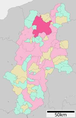
 Location of Nagano in Nagano Prefectur | |
| Coordinates: 36°38′N 138°11′E / 36.633°N 138.183°ECoordinates: 36°38′N 138°11′E / 36.633°N 138.183°E | |
| Kintra | Japan |
| Region | Chūbu (Kōshin'etsu) |
| Prefectur | Nagano Prefectur |
| Govrenment | |
| • Mayor | Shōichi Washizawa |
| Area | |
| • Total | 834.85 km2 (322.34 sq mi) |
| Population (Aprile 1, 2011[1]) | |
| • Total | 387,146 |
| • Density | 460/km2 (1,200/sq mi) |
| Symbols | |
| • Tree | Tilia japonica |
| • Flouer | Aiple |
| Time zone | UTC+9 (Japan Staundart Time) |
| City Hall Address | 1613 Midori-chō, Nagano-shi, Nagano-ken 380-8512 |
| Website | Ceety o Nagano |
Nagano (長野市 Nagano-shi), the caipital ceety o Nagano Prefectur, is locatit in the northren pairt o the prefectur near the confluence o the Chikuma an the Sai rivers, on the main Japanese island o Honshū.
As o Aprile 1, 2011, the ceety haes an estimatit population o 387,146 an a population density o 460 persons per km². The tot aurie is 834.85 km².
Sister ceety
 Clearwater, Florida, Unitit States
References
- ↑ "市政情報 > 市の沿革・概要 > 人口・面積・自然". Nagano official website (in Japanese). Nagano City. Archived frae the original on 19 October 2011. Retrieved 18 September 2011.

