Centro Region, Portugal
Appearance
| Centro | |
| Região Centro | |
| Region | |
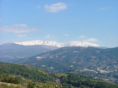
Symbolic o the Central Region, the Serra da Estrela the heichest peak/muntain range in continental Portugal
| |
| Name oreegin: centro, Portuguese for centre | |
| Kintra | |
|---|---|
| Region | Centro |
| Capital | Coimbra |
| - elevation | 119 m (390 ft) |
| - coordinates | 40°12′28″N 8°25′34″W / 40.20778°N 8.42611°WCoordinates: 40°12′28″N 8°25′34″W / 40.20778°N 8.42611°W |
| Lowest point | Sea level |
| - location | Atlantic Ocean |
| Area | 28,462 km2 (10,989 sq mi) |
| Population | 2,327,026 (2011) |
| Density | 81.76/km2 (212/sq mi) |
| Timezone | WET (UTC+0) |
| - summer (DST) | WEST (UTC+1) |
| ISO | PT |
| NUTS | PT16 |
| GDP per caipita (PPS) | € 15,300 (2006)[1] |
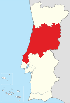
Location o the Centro Region in context o the naitional borders
| |
| Website: https://www.ccdrc.pt/ | |
| Statistics frae INE (2005); geographic detail from Instituto Geográfico Português (2010) | |
The Centro Region (Portuguese: Região Centro, IPA: [ʁɨʒiˈɐ̃w ˈsẽtɾu]) is a region in central Portugal, an its caipital is Coimbra. Ither local ceeties wi major admeenistrative status inside this region are Aveiro, Viseu, Leiria, Castelo Branco an Guarda. It is ane o seiven Regions o Portugal (NUTS II subdiveesions). This is ane o the regions o Europe, considered bi the European Union for statistical an geografical purposes. Its population in 2011 totalled 2,327,026 inhabitants[2], an its aurie is 28,462 km² (densitie o 82 inhabitants per square kilometre).
References
[eedit | eedit soorce]- Notes
Freemit airtins
[eedit | eedit soorce]- Centro de Portugal (Offeecial Centro Tourism steid)
- Região Centro Archived 2011-05-18 at the Wayback Machine (Aboot Centro region)


