Azores
Azores Açores | |
|---|---|
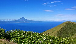
 Munt Pico an the green laundscape, emblematic o the airchipelago o the Azores | |
| Etymology: açor, Portuguese for the northren goshawk (Accipiter gentilis, pt:Açor), a species o raptor | |
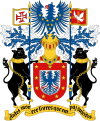
| Motto(s): Antes morrer livres que em paz sujeitos (Scots: "Raither dee free nor subjectit in peace") | |
 Location o the Azores relative tae Portugal (green) an the rest o the European Union (daurk blue) | |
| Coordinates: 38°36′N 28°00′W / 38.6°N 28°WCoordinates: 38°36′N 28°00′W / 38.6°N 28°W | |
| Kintra | |
| Autonomous Region | |
| Region | Atlantic Ocean |
| Subregion | Mid-Atlantic Ridge |
| Poseetion | Azores Plateau |
| Settlement | 15 August 1432 |
| Admeenistrative autonomy | c. 1895 |
| Poleetical autonomy | 4 September 1976 |
| Caipitals | Ponta Delgada, Horta, Angra do Heroísmo |
| Municipalities | Calheta, Lagoa, Lajes das Flores, Lajes do Pico, Madalena, Nordeste, Povoação, Praia da Vitória, Ribeira Grande, Santa Cruz da Graciosa, Santa Cruz das Flores, São Roque, Velas, Vila do Corvo, Vila do Porto, Vila Franca do Campo |
| Govrenment | |
| • Preses (Govrenment) | Vasco Cordeiro |
| Area | |
| • Total | 2333 km2 (901 sq mi) |
| Population (2012) | |
| • Total | 245,746 |
| • Density | 110/km2 (270/sq mi) |
| Time zone | UTC−1 (AZOT) |
| • Summer (DST) | AZOST (UTC) |
| Postal code | 9XXX-XXX |
| Area code(s) | (+351) 29X XX XX XX[1] |
| HDI (2017) | 0.795[2] high · 7th |
| Date format | dd-mm-yyyy |
| Drives on the | richt |
| Demonym | Azorean |
| Haliday | 51st day (Monanday) follaein Easter (Dia da Região Autónoma dos Açores) |
| Anthem | A Portuguesa (national) Hino dos Açores (regional) |
| Currency | Euro (€)[3] |
| Website | www.azores.gov.pt |
| Geografic detail frae CAOP (2010)[4] produced by Instituto Geográfico Português (IGP) | |
The Airchipelago o the Azores (UK /əˈzɔːrz/ ə-ZORZ, US /ˈeɪzɔːrz/ AY-zorz; Portuguese: Açores, IPA: [ɐˈsoɾɨʃ]) is composed o nine wee volcanic islands situatit in the middle o the North Atlantic Ocean, an is locatit aboot 1,500 km (930 mi) wast frae Lisbon an aboot 3,900 km (2,400 mi) east frae the east coast o North Americae. The islands, an their economic exclusion zone, form the Autonomous Region o the Azores, ane o the twa autonomous regions o Portugal. Its main industries are: agricultur, dairy fermin (for cheese an butter products primarily), minor livestock ranchin, fishin an tourism, whilk is becomin the major service activity in the region; eikit tae whilk, the govrenment o the Azores employs a lairge percentage o the population directly or indirectly in mony aspects o the service an tertiary sectors.
References
[eedit | eedit soorce]Notes
[eedit | eedit soorce]- ↑ "What is Azores dialing code?". happyzebra.com. Archived frae the original on 2 Apryle 2015. Retrieved 30 Juin 2014.
- ↑ "Sub-national HDI - Area Database - Global Data Lab". hdi.globaldatalab.org (in Inglis). Retrieved 13 September 2018.
- ↑ Till 2002, the Portuguese escudo wis uised in financial transactions, an till 1910 the Portuguese real wis the siller used by the monarchy o Portugal.
- ↑ IGP, ed. (2010), Carta Administrativa Oficial de Portugal (in Portuguese), Lisbon, Portugal: Instituto Geográfico Português, archived frae the original on 21 May 2011, retrieved 1 January 2012 Unknown parameter
|deadurl=ignored (help) Archived 2014-07-03 at the Wayback Machine
| This Portugal-relatit airticle is a stub. Ye can help Wikipaedia bi expandin it. |


