Camarillo
Appearance
Camarillo, Californie | |
|---|---|
 Leuking sootheast across Camarillo frae the northwestren hills on a warm sunny day in late October | |
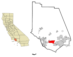
 Location in Ventura Coonty an the state o Californie | |
| Coordinates: 34°14′N 119°2′W / 34.233°N 119.033°WCoordinates: 34°14′N 119°2′W / 34.233°N 119.033°W | |
| Kintra | USA |
| State | Californie |
| Coonty | Ventura |
| Area | |
| • Total | 50.617 km2 (19.543 sq mi) |
| • Laund | 50.577 km2 (19.528 sq mi) |
| • Water | 0.040 km2 (0.015 sq mi) 0.08% |
| Elevation | 54 m (177 ft) |
| Population (2010) | |
| • Total | 65,201 |
| • Density | 1,300/km2 (3,300/sq mi) |
| Time zone | UTC-8 (PST) |
| • Summer (DST) | UTC-7 (PDT) |
| ZIP code | 93010-93012 |
| Area code(s) | 805 |
| FIPS code | 06-10046 |
| GNIS feature ID | 1652682 |
| Website | ci.camarillo.ca.us |
Camarillo, (/[unsupported input]ˌkæməˈriːoʊ/ "Kamma-Ree-Oh"), is a ceety o Californie wi a population o 57,084 as o 2000, an 65,201 in 2010.[1]
References
[eedit | eedit soorce]| Wikimedia Commons haes media relatit tae Camarillo, California. |
| This Unitit States-relatit airticle is a stub. Ye can help Wikipaedia bi expandin it. |

