
Kapan
Kapan | |
|---|---|
 Kapan wi Munt Khustup in the backgrund | |
 Kapan Location o Kapan in Armenie | |
| Coordinates: 39°12′04″N 46°24′54″E / 39.20111°N 46.41500°E | |
| Kintra | |
| Marz (Province) | Syunik |
| Govrenment | |
| • Mayor | Arthur Atayan |
| Area | |
| • Total | 35.70 km2 (13.78 sq mi) |
| Elevation | 905.5 m (2,970.8 ft) |
| Population (2010) | |
| • Total | 45,488 |
| • Density | 1,300/km2 (3,300/sq mi) |
| Time zone | UTC+4 (GMT+4) |
| • Summer (DST) | UTC+5 (GMT+5) |
| Website | Kapan Offeecial Wabsteid |
Kapan (Armenie: Կապան); umwhile names include Ghapan, Kafan, Zangezur an Madan, is the caipital o the Syunik Province (marz) at the sooth o Armenie. The ceety is locatit 316 km frae the caipital Yerevan. Wi a population o 45,500 (2009), Kapan is the maist muckle ceety in Syunik province an soothren Armenie.
Etymology[eedit | eedit soorce]
The wird Kapan oreeginates frae the Armenie verb kapel (կապել), which mean "tae lock," an pynts tae an auld Armenian geographic term for valleys surroondit bi interlocked muntain chains.[2]
History[eedit | eedit soorce]
The aurie aroond Kapan wis first mentioned in the 5t century. In the 10t century, the ruler o Syunik, Prince Smbat II, muivit here an foondit the Syunik, or Bahkskoe kinrick, proclaimin hissel king in 970. The ceety is associatit wi Davit Bek, an 18t century Armenian leader whose wars against the Turkis an Persian Muslim invaders wur focht aroond Syunik. His leeberation campaign wi a haundful o brave men began in 1722, an attractit thoosans o patriots who leeberatit Syunik.[3] Near tae Kapan is the castle in which Bek dee'd in 1728.
Kapan, as a ceety, formit in the 19t century frae the merger o several veelages.
Economy[eedit | eedit soorce]
Wi a population o aroond 45,500, Kapan is strugglin tae cope wi the realities o post-Nagorno-Karabakh War an post-Soviet society. Housomeivver, thare are signs o growt an development. Kapan is primarily a minin ceety, hence its Persie name o the Qajar time معدن (Ma'dan, meanin "mine"). Kapan's industry is dependent on the newly privatisit polymetallic deposit, tho additional operations hae developit includin minin support services, commercial scale animal husbandry, an an expandin retail sector. The furniture an textile industries hae grown in recent years.
Kapan wis an remains a centre o production o mony non-ferrous metals. Commercial development o the local deposits began in 1890. Armenie entrepreneurs an French minin ingineers obtained concessions tae the copper mines an a copper-ore processin plant wis biggit in the ceety.
Geografie an climate[eedit | eedit soorce]
Kapan is the lairgest ceety in soothren Armenie. Locatit in the east o Syunik Province in the Voghji valley it lies on the sooth-eastren slopes o the Zangezur Muntain Range atween its spurs, the Bargushatskim an Meghri ridges. Tae the sooth o the ceety is Munt Khustup (3201 m).
| Climate data for Kapan | |||||||||||||
|---|---|---|---|---|---|---|---|---|---|---|---|---|---|
| Month | Jan | Feb | Mar | Apr | May | Jun | Jul | Aug | Sep | Oct | Nov | Dec | Year |
| Average heich °C (°F) | 7.1 (44.8) |
8.4 (47.1) |
11.7 (53.1) |
17.1 (62.8) |
21.8 (71.2) |
25.8 (78.4) |
29.3 (84.7) |
29.3 (84.7) |
24.4 (75.9) |
19.8 (67.6) |
13.1 (55.6) |
9.0 (48.2) |
18.1 (64.5) |
| Average law °C (°F) | −13.0 (8.6) |
−12.0 (10.4) |
−8.0 (17.6) |
−1.0 (30.2) |
4.0 (39.2) |
8.0 (46.4) |
11.0 (51.8) |
11.0 (51.8) |
7.0 (44.6) |
1.0 (33.8) |
−6.0 (21.2) |
−10.0 (14.0) |
−0.7 (30.8) |
| Average precipitation mm (inches) | 28 (1.1) |
32 (1.3) |
60 (2.4) |
80 (3.1) |
96 (3.8) |
68 (2.7) |
31 (1.2) |
30 (1.2) |
43 (1.7) |
55 (2.2) |
40 (1.6) |
27 (1.1) |
590 (23.4) |
| Average precipitation days | 7 | 7 | 11 | 12 | 15 | 10 | 4 | 4 | 7 | 8 | 7 | 6 | 98 |
| Source: World Meteorological Organisation (UN) [4] | |||||||||||||
Notable landmarks[eedit | eedit soorce]
- Vahanavank monastery
- Baghaberd an Halidzor Fortresses.
- Tatev Monastery - This monastery, situatit northwast o Kapan wis foondit in the nint century in the place o an auncient tabernacle well-kent in auncient times. It is locatit strategically, owerleukin a deep river gorge.
- Monument tae David Bek.
- Kapan College o Muisic
- Kapan Airchaeological an Ethnographic Museum
- Kapan Theatre
Transportation[eedit | eedit soorce]
The ceety is connectit tae Iran bi road. In late 2008, the road wis redevelopit atween Kapan an Kajaran-Meghri. Frae the ceety is anerlie the nanoperatin railwa line Kapan-Kovsakan-Midzhnavan.
Prior tae the Karabakh war, a sma airport wis uised tae accommodate the aircraft YAK-40 an AN-14 cargo.
The ither nearest airport is locatit 62 kilometers tae the north.
Sport[eedit | eedit soorce]
- Gandzasar F.C. - fitbaa club
Notable fowk frae Kapan[eedit | eedit soorce]
- Tatoul Markarian - Armenian ambassador tae Unitit States
Sister ceeties[eedit | eedit soorce]
Gallery[eedit | eedit soorce]
- Kapan
-
 Monument tae David Bek
 -
 Monument tae Garegin Njdeh
 -
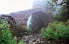 Historic brig in Kapan
 -
 Vahanavank monastery
 -
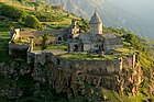 Tatev Monastery near Kapan


References[eedit | eedit soorce]
- ↑ "Syunik regional e-Govrenance Seestem" (in Armenian). Syunik Province provincial govrenment. Click on airtin enteetled "Համայնքներ" (commonty) an sairch for the place bi Armenie name.
- ↑ Western Armenian Dictionary & Phrasebook: Armenian-English/English-Armenian (Hippocrene Dictionary and Phrasebook). 2006. p. 86
- ↑ "Капан" (in Russian). www.abp.am. Archived frae the original on 5 Mey 2010. Retrieved 28 August 2009.CS1 maint: unrecognised leid (link)
- ↑ "World Weather Information Service – Kapan". Unitit Naitions. Archived frae the original on 24 Julie 2011. Retrieved 29 December 2010.
- Kiesling, Rediscoving Armenia, p. 100-102, available online at the US embassy to Armenia's website Archived 2008-06-26 at the Wayback Machine
- Report of the results of the 2001 Armenian Census, Naitional Statistical Service o the Republic o Armenie
- World Gazeteer: Armenia[deid airtin] – World-Gazetteer.com
Freemit airtins[eedit | eedit soorce]
- American Corner Kapan Archived 2012-12-29 at Archive.today
Coordinates: 39°12′04″N 46°24′54″E / 39.20111°N 46.41500°E

| Wikimedia Commons haes media relatit tae Kapan. |