
Ararat Province
Ararat Արարատ | |
|---|---|
 Location o Ararat athin Armenie | |
| Coordinates: 39°55′N 44°43′E / 39.917°N 44.717°E | |
| Kintra | Armenie |
| Caipital | Artashat |
| Govrenment | |
| • Govrenor | Aramayis Grigoryan(2013) |
| Area | |
| • Total | 2096 km2 (809 sq mi) |
| Area rank | 9t |
| Population (2002) | |
| • Total | 252,665 |
| • Rank | 5t |
| • Density | 120/km2 (310/sq mi) |
| Time zone | UTC+04 |
| • Summer (DST) | UTC+05 |
| Postal code | 0601-0823 |
| ISO 3166 code | AM.AR |
| FIPS 10-4 | AM02 |
| Website | ararat.gov.am |
Ararat (Armenie: Արարատ) is a province (marz) o Armenie wi its caipital in Artashat. Namit efter Munt Ararat, the province borders Turkey tae the wast an Azerbaijan's Nakhchivan Autonomous Republic tae the sooth. It surroonds the Karki exclave o Nakhichevan which haes been controlled bi Armenie syne its captur in Mey 1992 durin the Nagorno-Karabakh War.
Twa umwhile Armenie caipitals are locatit in this region (Artashat (Artaxata) an Dvin) as well as the Khor Virap monastery, significant as the place o Gregory the Illuminator's 13-year impreesonment an the closest point tae Munt Ararat athin Armenie borders.
Ararat borders the follaein marzer:
- Armavir - northwast
- Kotayk - north
- Gegharkunik - east
- Vayots Dzor - sootheast
Ararat an aw borders Yerevan in the north, atween its borders wi Armavir an Kotayk.
In 1993 an again in 1995, CYMA (Canadian Youth Mission to Armenia) operatit frae Ararat province, biggin commonty centres, renovatin schuils, managin a childer's day camp an distributin aid tae faimilies affectit bi the Nagorno-Karabakh War. CYMA co-foonders Airchbishop Hovnan Derderian an Ronald Alepian chose Ararat due tae its well-organisit youth muivement.
Commonties[eedit | eedit soorce]
The province o Ararat consists o the follaein 97 commonties (hamaynkner), o which 4 (bauld in the table) are considered urban an 93 are considered rural.[1] The diveesion belaw is bi raion, the admeenistrative subdiveesions o Armenie afore 1995.
Gallery[eedit | eedit soorce]
- Ararat
-
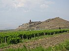 Khor Virap Monastery
 -
 Apricot ferms
 -
 Arevshat kirk
 -
 Near the auncient ceety o Dvin
 -
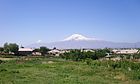 Ararat frae Nor Kyurin veelage


References[eedit | eedit soorce]
- Report of the results of the 2001 Armenian Census, Naitional Statistical Service o the Republic o Armenie
- ↑ "RA Ararat Marz" (PDF). Marzes of the Republic of Armenia in Figures, 2002-2006. National Statistical Service of the Republic of Armenia. 2007. Cite has empty unkent parameter:
|1=(help)
See an aw[eedit | eedit soorce]
| Marzer (մարզեր) | ||
|---|---|---|
| Ceety wi special status |
| |