
Gegharkunik Province
Gegharkunik Գեղարքունիք | |
|---|---|
 Location o Gegharkunik athin Armenie | |
| Coordinates: 40°25′N 45°12′E / 40.417°N 45.200°E | |
| Kintra | Armenie |
| Caipital | Gavar |
| Govrenment | |
| • Govrenor | Nver Poghosian |
| Area | |
| • Total | 5348 km2 (2,065 sq mi) |
| Area rank | 1st |
| Population (2002) | |
| • Total | 215,371 |
| • Rank | 7t |
| • Density | 40/km2 (100/sq mi) |
| Time zone | UTC+04 |
| • Summer (DST) | UTC+05 |
| Postal code | 1201–1626 |
| ISO 3166 code | AM.GR |
| FIPS 10-4 | AM04 |
| Website | gegharkunik.gov.am |
Gegharkunik (Armenie: Գեղարքունիք) is a province (marz) o Armenie. Gegharkunik wis namit efter Gegham. Gegham wis a Haykazuni King an fift generation efter Hayk. Gegham wis the faither o Sisak o Syunid nobles an Arma the grandfaither o Ara the Bonnie. Geghama muntains an Geghama lake, presently Lake Sevan, wur namit efter Gegham.
Gegharkunik Province is in the east o Armenie, borderin Azerbaijan. At 5,348 km², Gegharkunik is the lairgest province in Armenie bi aurie. Housomeivver, thareby 1,278 km² o its territory is covered bi Lake Sevan, the lairgest loch in the Caucasus an a major tourist attraction o the region. It haes a exclave athin Azerbaijan, Artsvashen, whilk came unner Azerbaijani control in the Nagorno-Karabakh War. Its caipital is Gavar.
Specially protectit auries[eedit | eedit soorce]
Sevan National Park[eedit | eedit soorce]
Sevan Naitional Pairk wis established in 1978 tae pertect Lake Sevan. It occupees the territories o the Lake Sevan comprisin the bed o intermontane concavity o Sevan an those freed frae its bed. The aurie comprises 1501 square kilometers, o whilk 24.9 thoosan hectares are lakeside land. It is surroondit wi the slopes o muntain chains o Areguni, Geghama, Vardenis, Pambak an Sevan. Some 1600 plant an 330 ainimal species are foond here. The pairk is dividit intae 3 zones: a reserve, a recreation zone, an a zone for economic uise.
Akhnabad Yew Grove State Reservation[eedit | eedit soorce]
Akhnabad Yew Grove State Reservation wis established in 1958. It is locatit on Mt. Tsaghkot o the Miapor muntain range near Aghavnavank. The main species o the reservation is yew (taxus baccata L.). On the territory o the reservation yew grows in the mixed wid (beech, aik, maple etc.). Trees 300–400 year auld, 25 m heich an wi 70–90 cm trunk diameter can be foond thare.
Getik State Reservation[eedit | eedit soorce]
Getik State Reservation wis established in 1971. Main protectit objects are forest fauna.
Juniper Forest State Reservation[eedit | eedit soorce]
Juniper Forest State Reservation wis established in 1958. Main pertected object is relict aiten, as weel as ither numerous species.
Commonties[eedit | eedit soorce]
The province o Gegharkunik consists o the follaein 92 commonties (hamaynkner), o whilk 5 (bauld in the table) are considered urban an 87 are considered rural.[1] The diveesion belaw is bi raion, the admeenistrative subdiveesions o Armenie afore 1995. Thare settlements lik Chichakli an aw.
| Gavar | Sevan | Chambarak | Martuni | Vardenis |
|---|---|---|---|---|
|
Gallery[eedit | eedit soorce]
- Gegharkunik
-
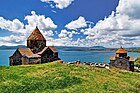 Sevanavank, 874 AD
 -
 Hayravank, 9t century
 -
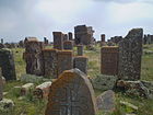 Noraduz cemetery, 10t century
 -
 Sevan peninsulae
 -
 Ttujur veelage


References[eedit | eedit soorce]
- Report of the results of the 2001 Armenian Census, Naitional Statistical Service o the Republic o Armenie
- ↑ "RA Gegharkunik Marz" (PDF). Marzes of the Republic of Armenia in Figures, 2002–2006. National Statistical Service of the Republic of Armenia. 2007.
Freemit airtins[eedit | eedit soorce]
- Gegharkunik Marz Tourist Guide
- Gegharkunik destrict Archived 2010-08-22 at the Wayback Machine
| Wikimedia Commons haes media relatit tae Gegharkunik marz. |
Caipital: Gavar | ||
| Gavar | | |
| Sevan | ||
| Chambarak | ||
| Martuni | ||
| Vardenis |
| |
| Marzer (մարզեր) | ||
|---|---|---|
| Ceety wi special status |
| |