Zarrentin am Schaalsee
Appearance
Zarrentin am Schaalsee | |
|---|---|
| Coordinates: 53°32′N 10°55′E / 53.533°N 10.917°ECoordinates: 53°32′N 10°55′E / 53.533°N 10.917°E | |
| Kintra | Germany |
| State | Mecklenburg-Vorpommern |
| Destrict | Ludwigslust-Parchim |
| Municipal assoc. | Zarrentin |
| Subdivisions | 12 |
| Govrenment | |
| • Mayor | Marian Borowkoff |
| Area | |
| • Total | 91.89 km2 (35.48 sq mi) |
| Elevation | 40 m (130 ft) |
| Population (2021-12-31)[1] | |
| • Total | 5,421 |
| • Density | 59/km2 (150/sq mi) |
| Time zone | CET/CEST (UTC+1/+2) |
| Postal codes | 19246 |
| Diallin codes | 038851 |
| Vehicle registration | LWL |
| Website | www.zarrentin.de |


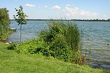
Zarrentin am Schaalsee is a toun in the Ludwigslust-Parchim destrict, in Mecklenburg-Vorpommern, Germany. It is situatit on the Schaalsee lake, 19 km sootheast o Ratzeburg, an 34 km wast o Schwerin.
History
[eedit | eedit soorce]Atween 1982 an 1990 Zarrentin servit as East German inner German border crossin for cars travellin alang the day's Bundesautobahn 24 atween the East German Democratic Republic, or Wast Berlin an the Wast German Federal Republic o Germany. The traffic wis subject tae the Interzonal traffic regulations, that atween Wast Germany an Wast Berlin follaeed the special regulations o the Transit Greement (1972).
Template:Touns an municipalities in Ludwigslust-Parchim (destrict)
References
[eedit | eedit soorce]- ↑ "Bevölkerungsstand der Kreise, Ämter und Gemeinden 2021" (XLS) (in German). Statistisches Amt Mecklenburg-Vorpommern. 2022.
| Wikimedia Commons haes media relatit tae Zarrentin am Schaalsee. |


