Woodley Park
The "Scots" that wis uised in this airticle wis written bi a body that haesna a guid grip on the leid. Please mak this airticle mair better gin ye can. |
This airticle needs mair soorces fur verification. |
Old Woodley Park Historic District | |
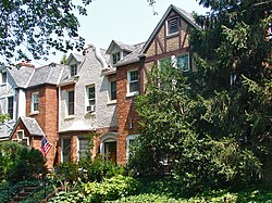
 Houses in the historic district | |
 | |
| Location | Roughly bounded by Rock Creek Park, 24th St., 29th St., Woodley Rd. and Cathedral Ave., NW., Washington, District of Columbia |
|---|---|
| Aurie | 54 acre (22 ha) |
| Biggit | 1905 |
| Airchitectural style | Late 19th And 20th Century Revivals[2] |
| NRHP Reference # | 90000856[1] |
| Addit tae NRHP | June 15, 1990 |
Woodley Park is a neeburheid in Northwest, Washington, D.C.. It is boondit on the north bi Woodley Road an Klingle Road, on the east bi the National Zoo an Rock Creek Park, on the sooth bi Calvert Street, on the soothwast bi Cleveland Avenue, an on the wast bi 34t Street.
Adjining neeburheids is Cleveland Park tae the north, Mount Pleasant an Adams Morgan tae the east, Kalorama tae the sooth, Woodland-Normanstone Terrace tae the soothwast, an Massachusetts Heights tae the wast.
Woodley Park is serrt bi the Woodley Park-Zoo/Adams Morgan Metro station, atween Dupont Circle an Cleveland Park on the Reid Line.

Straddlin Connecticut Avenue sooth o the National Zoo is a neeburheid of fine early 20t-century row hooses, a thrawback tae the days mair nor a century back whan developers howpit that this wide avenue that runs nowrthwarts tae the Maryland border wad be a boulevard lined wi elegant hames. Modren-day Connecticut Avenue north o the smaw Woodley Park historic destrict, housomeivver, is nou maistly filled wi heich rent, heich rise apairtment hooses — awtho the city's heicht limitation restricts thaim tae nae mair nor aicht stories, they are considered heich-rise bi Washington staundarts. Tae the east, the neebourheid's curvit streets owerhang Rock Creek Park. On the wast, they bend on the slope leadin tae the heichts o Mt. Saint Albans, the steid o Washington National Cathedral.
On Connecticut Avenue, row hooses alang the street hae been convertit intae commercial properties, includin restaurants, offices an retail shops. Twa muckle hotels are locatit on Calvert Street (the Omni Shoreham Hotel) an Woodley Road (the Marriott Wardman Park hotel, the seicont maistmuckle hotel in D.C.).
The airt wis cried efter Woodley House, biggit bi Philip Barton Key (the uncle o Francis Scott Key) in 1801. Woodley haes hoosit mony political elites frae Preses Grover Cleveland til Secont Warld War Secretar o War Henry Stimson. Nouadays Woodley House serves as the librar an administrativ biggin o the Maret School.
The Woodley Park Community Association wis established tae support the in-toun neeburheid quality o life in Woodley Park. It haes several hunder members an wirks on issues o general neebourheid interest.
Eddication
[eedit | eedit soorce]The District of Columbia Public Schools is the public schuil system. Oyster Adams Bilingual Elementary School is the neeburheid elementar schuil, shapit in 2007 bi the merger o James F. Oyster Bilingual Elementary School in Woodley Park an John Quincy Adams Elementary School in Adams Morgan.[3]
References
[eedit | eedit soorce]- ↑ "National Register Information System". National Register of Historic Places. National Park Service. 9 Julie 2010.
- ↑ Field, Cynthia. "NRHP Nomination Form" (PDF). April 1990. National Park Service. Retrieved 27 Januar 2014.
- ↑ "About Us Archived 2014-11-06 at the Wayback Machine" (). Oyster Adams Bilingual Elementary School. Retrieved on November 6, 2014.
Freemit airtins
[eedit | eedit soorce]| Wikimedia Commons haes media relatit tae Woodley Park, Washington, D.C.. |
Coordinates: 38°55′42.4″N 77°3′21.5″W / 38.928444°N 77.055972°W
