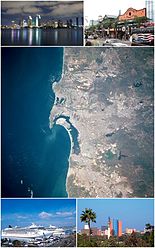
San Diego-Tijuana
Coordinates: 32°32′31.87″N 117°01′46.63″W / 32.5421861°N 117.0296194°W
San Diego–Tijuana | |
|---|---|
 Primary urban aurie o San Diego–Tijuana | |
| Country | |
| State | |
| Principal ceeties | San Diego - Tijuana - Chula Vista - Carlsbad - San Marcos - National City - Rosarito Beach - Tecate |
| Area | |
| • Total | 41,940 km2 (16,194 sq mi) |
| Elevation | 0 - 1,991 m (0 - 6,533 ft) |
| Population (2012 est.)[1] | |
| • Density | 394/km2 (1020/sq mi) |
| • Metro | 5271078 (19t) |
| Time zone | UTC-8 (PST) |
San Diego–Tijuana, kent as Tijuana–San Diego an aw, is an internaitional metropolitan aurie, or conurbation,[2] on the border atween the twa lairge North American coastal ceeties o San Diego, Californie, Unitit States an Tijuana, Baja California, Mexico. The region consists o San Diego Coonty in the Unitit States an the municipalities o Tijuana, Rosarito Beach, an Tecate in Mexico. The 2012 population o the region wis 5,271,078, makkin it the lairgest bi-national conurbation shared atween the Unitit States an Mexico an the third lairgest in the warld.[3] The region maintains global ceeties an is kent for its cultur, history, technological innovations, natural geografie, an tourism.
References
[eedit | eedit soorce]- ↑ "World Gazatteer; San Diego-Tijuana". World Gazetteer. Archived frae the original on 1 October 2007. Retrieved 20 Mairch 2011.
- ↑ "California Coast, Los Angeles to San Diego Bay". NASA.
- ↑ Loucky, James, ed. (2008). Transboundary policy challenges in the Pacific border regions of North America. University of Calgary Press. p. 8. ISBN 1-55238-223-0. Retrieved 19 Februar 2011. Check
|editor2-link=value (help); Missin|editor1=(help)
Freemit airtins
[eedit | eedit soorce]| Fin mair about San Diego-Tijuana at Wikipedia's sister projects | |
| Definitions an owersettins from Wiktionary | |
| Media frae Commons | |
| Learning resources frae Wikiversity | |
| News stories frae Wikinews | |
| Quotations frae Wikiquote | |
| Source texts frae Wikisource | |
| Textbooks frae Wikibooks | |
- Organisations

