Reid Sea (state)
Reid Sea البحر الأحمر al-Bahr al-Ahmar | |
|---|---|
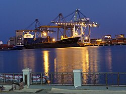
 Port Sudan | |
 Location in Sudan. | |
| Coordinates: 19°35′N 35°37′E / 19.583°N 35.617°E | |
| State | |
| Region | Kassala (Eastren Sudan) |
| Capital | Port Sudan |
| Govrenment | |
| • Govrenor | Mohmed Taheir Aila |
| Area | |
| • Total | 218887 km2 (84,513 sq mi) |
| Population (2010 (est.)) | |
| • Total | 1,396,000 |
| Time zone | UTC+3 (EAT) |
Reid Sea (Arabic: البحر الأحمر Al Baḥr al Aḥmar) is ane o the 17 wilayat or states o Sudan.[1] It haes an aurie o 212,800 km²[2] an an estimatit population of 1,396,000 (2010). Port Sudan is the capital of the state.[2] Sudan claims, but does no control the Hala'ib Triangle, a region disputit atween Sudan an Egyp. The oreeginal inhabitants o the State are the Beja Tribes, who constitute abuin 65% o the current population wi lawer walth an pouer in the region.
Geographically, in the east, borderin the state, is the Reid Sea. Inland, muntains run frae north tae sooth, which are interruptit bi arid plains. Tae the northwast is the Nubie Desert. The Siyal Islands are locatit in the disputit aurie atween Egyp an Sudan in the northeast.
The Sudanese state is dividit intae the aicht admeenistrative auries: Bur Sudan (Port Sudan), Gebiet Elma'din, Halayib, Haya, Sawakin, Sinkat ,Gunob Awlieb , Derodieb, Tokar and Ageeg.
References
[eedit | eedit soorce]- Notes
- ↑ "Sudan States"
- ↑ a b "Red Sea State" on the Republic of Sudan website
