Pangaio
Appearance
Pangaio Παγγαίο | |
|---|---|
| Coordinates: 40°57′N 24°09′E / 40.950°N 24.150°ECoordinates: 40°57′N 24°09′E / 40.950°N 24.150°E | |
| Kintra | Greece |
| Admeenistrative region | East Macedonie an Thrace |
| Regional unit | Kavala |
| Area | |
| • Municipality | 698.0 km2 (269.5 sq mi) |
| Population (2011)[1] | |
| • Municipality | 32085 |
| • Municipality density | 46/km2 (120/sq mi) |
| • Municipal unit | 4251 |
| Time zone | UTC+2 (EET) |
| • Summer (DST) | UTC+3 (EEST) |
| Vehicle registration | ΚΒ |
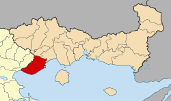
Pangaio (Greek: Παγγαίο) is a municipality in the Kavala regional unit, Greece, namit efter the Pangaion hills. The seat o the municipality is in Eleftheroupoli.[2]
Municipality
[eedit | eedit soorce]The municipality Pangaio wis formit at the 2011 local govrenment reform bi the merger o the follaein 5 umwhile municipalities, that became municipal units:[2]
- Eleftheres
- Eleftheroupoli
- Orfani
- Pangaio
- Piereis
Province
[eedit | eedit soorce]The province o Pangaio (Greek: Επαρχία Παγγαίου) wis ane of the provinces o the Kavala Prefectur. It haed the same territory as the present municipality, except a pairt o the municipal unit Eleftheroupoli.[3] It wis abolished in 2006.
References
[eedit | eedit soorce]- ↑ a b "Απογραφή Πληθυσμού - Κατοικιών 2011. ΜΟΝΙΜΟΣ Πληθυσμός" (in Greek). Hellenic Statistical Authority.
- ↑ a b Kallikratis law Archived 2017-04-27 at the Wayback Machine Greece Ministry of Interior (in Greek)
- ↑ Detailed census results 1991 PDF (39 MB) (in Greek) (in French)


