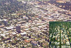
Palo Alto, Californie
Palo Alto | |
|---|---|
| Ceety o Palo Alto | |
 Palo Alto | |
 Location in Santa Clara Coonty an the State o Californie | |
| Coordinates: 37°25′45″N 122°8′17″W / 37.42917°N 122.13806°WCoordinates: 37°25′45″N 122°8′17″W / 37.42917°N 122.13806°W | |
| Kintra | Unitit States |
| State | Californie |
| Coonty | Santa Clara |
| Incorporatit | Aprile 23, 1894[1] |
| Named for | El Palo Alto |
| Govrenment | |
| • Teep | Cooncil-Manager |
| • Bodi | Ceety cooncil members:[2]
|
| Area | |
| • Total | 66.787 km2 (25.787 sq mi) |
| • Laund | 61.858 km2 (23.884 sq mi) |
| • Water | 4.929 km2 (1.903 sq mi) 7.38% |
| Elevation | 9 m (30 ft) |
| Population | |
| • Total | 64,403 |
| • Estimate (2013)[5] | 66,642 |
| • Density | 960/km2 (2,500/sq mi) |
| Time zone | UTC−8 (Paceefic) |
| • Summer (DST) | UTC−7 (PDT) |
| ZIP codes | 94301, 94303, 94304, 94306 |
| Aurie code | 650 |
| FIPS code | 06-55282 |
| GNIS featur IDs | 277572, 2411362 |
| Website | www |
Palo Alto (/ˌpɑːloʊˈɑːltoʊ/, /ˌpæloʊˈæltoʊ/; Spanish: palo: leeterally "stick", colloquial: "tree" an alto: "taw"; meanin: "taw tree") is a chairter ceety locatit in the northwast corner o Santa Clara Coonty, Californie, in the San Francisco Bay Aurie o the Unitit States.
References[eedit | eedit soorce]
- ↑ "California Cities by Incorporation Date". California Association of Local Agency Formation Commissions. Archived frae the original (Word) on 17 October 2013. Retrieved 25 August 2014.
- ↑ "City Council & Mayor". City of Palo Alto. Retrieved 12 Januar 2015.
- ↑ "2010 Census U.S. Gazetteer Files – Places – California". Unitit States Census Bureau.
- ↑ "Palo Alto". Geographic Names Information System. United States Geological Survey. Retrieved 7 October 2014.
- ↑ a b "Palo Alto (city) QuickFacts". United States Census Bureau. Archived frae the original on 24 Februar 2016. Retrieved 8 Februar 2015.


