
Othón P. Blanco, Quintana Roo
Othón P. Blanco | |
|---|---|
Municipality | |
 Emblem | |
 Location o Othón P. Blanco in Quintana Roo | |
 Othón P. Blanco Location o Othón P. Blanco in Quintana Roo | |
| Coordinates: 18°30′13″N 88°18′19″W / 18.50361°N 88.30528°W | |
| Kintra | |
| State | Quintana Roo |
| Municipal Seat | Chetumal |
| Municipality Foondit | 5 Mey 1898 |
| Named for | Othón P. Blanco Núñez de Cáceres |
| Govrenment | |
| • Municipal Preses[1] | Andrés Ruiz Morcillo |
| Area | |
| • Municipality | 17189.75 km2 (6,637.00 sq mi) |
| [2] | |
| Elevation | 10 m (30 ft) |
| Population (2010 [3]) | |
| • Municipality | 244,553 |
| • Density | 14/km2 (37/sq mi) |
| • Urban | 182,178 |
| Time zone | UTC-6 (Central Staundart Time) |
| • Summer (DST) | UTC-5 (Central Daylicht Time) |
| INEGI Code | 004 |
| Major Airport | Chetumal Airport |
| IATA Code | CTM |
| ICAO Code | MMCM |
| Website | Official Site |
| Municipalities o Quintana Roo | |
The municipality o Othón P. Blanco is ane o the ten subdiveesions (municipios) o the Mexican state o Quintana Roo. It is the fift-lairgest municipality in land aurie in Mexico, at 17,189.75 km² (6,637 sq mi),[2] occupyin mair nor a third o the entire state.[4] It haed a 2010 census population o 244,553 persons. Its municipal seat is the ceety o Chetumal, which serves as the state caipital an aw.
The municipal govrenment is heidit bi the municipal preses o Othón P. Blanco (mayor o Othón P. Blanco, aka mayor o Chetumal).
The municipality is namit efter Othón P. Blanco Núñez de Cáceres.
Major commonties
[eedit | eedit soorce]The 2010 census enumeratit 727 populatit localities plus 804 unpopulatit localities. The lairgest localities (ceeties, touns, an veelages) are leetit belaw.[3] In early 2011, housomeivver, the municipality wis split intae twa pairts, wi mony o the localities nou comprisin pairt o the newly-creatit Bacalar Municipality.
| Name | 2010 Census Population |
|---|---|
| Chetumal | 151,243 |
| Bacalar [tae Bacalar Municipality in 2011] | 11,048 |
| Calderitas | 5,326 |
| Nicolás Bravo | 4,011 |
| Javier Rojo Gómez | 2,911 |
| Álvaro Obregón | 2,869 |
| Limones [tae Bacalar Municipality in 2011] | 2,535 |
| Sergio Butrón Casas | 2,235 |
| Cacao | 2,056 |
| Xul-Ha | 2,037 |
| Maya Balam | 2,018 |
| Subteniente López | 1,915 |
| Pucté | 1,861 |
| Carlos A. Madrazo | 1,825 |
| Huay-Pix | 1,649 |
| Tot Municipality | 244,553 |
Ither commonties
[eedit | eedit soorce]Aircheological Steids
[eedit | eedit soorce]- Dzibanché
- Kohunlich
- Oxtankah
- Chakanbakán
- Kinichna
- Ichkabal
- Zamora
Ecoseestems
[eedit | eedit soorce]The vegetation foond in the municipality o Othon P. Blanco is maistly o medium forest, spannin maist o the interior o the municipality an thare are mair representative plant species are the sapodilla, the ramon, the guayabillo an Chaco, mair isolatit auries athin the municipality is populatit bi heich forest, whare you can fynd the siricote, the palo de tinte an mahogany, tae the soothwast o the toun are engagit in auries o rainfed agricultur an irrigation, the main crop o succarcane, alang wi the Caribbean coast can be tracit mainly mangroves.[5]
The fauna is rich an variet, amang the main species is the manatee, marine mammal that lives in bays an lagoons lictors an haes acome a seembol o the region, an ane can fynd species such as agouti, wild boar, white-tailed deer, otters, turtles an birds.
For the pertection o ainimal an plant species in Othon P. Blanco thare are three zones o ecological reserve, the aurie o Protection o Flora an Fauna Uaymil locatit on the northeast coast o the territory, near Mahahual, an the Manatee Sanctuary in the Bay o Chetumal an the Biosphere Reserve Banco Chinchorro.
Tourism
[eedit | eedit soorce]Locatit on the coast, the eco resort o Kabah-na affers anerlie fower cabins in a hexagon shape tae circulate the air an thatched ruifs which keep the interior temperatur ceul. A complex seestem o solar panels provides energy 24 oors a day as well as het watter. The resort affers restaurant, beach bar, ootdoor showers, hammocks, beach volleybaw, canoes, snorkelin equipment an mair.[6]
At Laguna de Bacalar is Rancho Encantado which is locatit on the edge o a lagoon. It consists o twal cabins palm-thatched roofs, handmade furnitur an decoratit wi Mexican accents. The cabins are surroondit bi tropical gardens in which live mair nor 150 species o birds amang the tropical fruit orchards.[7]
Gallery
[eedit | eedit soorce]-
 Río Hondo
 -
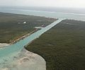 Aerial view o the Zaragoza Canal, the Bay o Chetumal an the Caribbean Sea
 -
 Bacalar Lagoon
 -
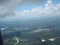 Junction o Highway 186 an 307 sooth o Laguna Bacalar


References
[eedit | eedit soorce]- ↑ Ayuntamiento de Othon P. Blanco Official website (In Spanish)
- ↑ a b The largest and smallest municipalities in land area Archived 2013-10-17 at the Wayback Machine Instituto Nacional Para el Federalismo y el Desarrollo Municipal Cite error: Invalid
<ref>tag; name "e-local.gob.mx" defined multiple times wi different content - ↑ a b 2010 census tables: INEGI Archived 2018-12-25 at the Wayback Machine Cite error: Invalid
<ref>tag; name "2010 census tables: INEGI" defined multiple times wi different content - ↑ Othón P. Blanco, Ubicación Geográfica Archived 2009-07-04 at the Wayback Machine
- ↑ Instituto Nacional de Estadística y Geografía. "Quintana Roo. Mapa de Agricultura y Vegetación". Archived frae the original (HTML) on 27 Januar 2012. Retrieved 12 October 2012.
- ↑ "Kabah-na". Mexico Desconocido (in Spanish). Mexico City: Grupo Editorial Impresiones Aéreas. 394: 33. 2009. ISSN 1870-9397. Unknown parameter
|month=ignored (help)CS1 maint: unrecognised leid (link) - ↑ "Rancho Encantado". Mexico Desconocido (in Spanish). Mexico City: Grupo Editorial Impresiones Aéreas. 394: 33. 2009. ISSN 1870-9397. Unknown parameter
|month=ignored (help)CS1 maint: unrecognised leid (link)
Chetumal (caipital) | ||
| Municipalities (seats) |  | |
| Places o interest | ||