Namiquipa
Appearance
Namiquipa | |
|---|---|
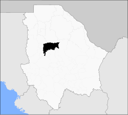
 Municipality o Namiquipa in Chihuahua | |
| Coordinates: 29°15′01″N 107°24′33″W / 29.25028°N 107.40917°W | |
| Kintra | |
| State | Chihuahua |
| Municipality | Namiquipa |
| Franciscan Mission | 1763 |
| Toun status | 1778 |
| Govrenment | |
| • Municipal Preses | Héctor Ariel Meixueiro Muñoz (PRI) |
| Elevation | 1888 m (6,194 ft) |
| Population (2005) | |
| • Total | 1,718 |
| Postal code | 31960 |
| Area code(s) | 659 |
| Demonym | Namiquipense |
Namiquipa is a toun in the Mexican state o Chihuahua. It serves as the municipal seat for the surroondin municipality o Namiquipa.
In the 2005 INEGI Census, the municipality reportit a tot population o 20,314, o whom 1,718 livit in the municipal seat.[1]
The oreegin o the dounset is an indigenous veelage cried Namiquipa, whaur, in 1763, Franciscan missionaries established a mission cried San Pedro de Alcántara de Namiquipa. It wis gien toun (villa) status in 1778.[1]
References
[eedit | eedit soorce]- ↑ a b "Namiquipa". Enciclopedia de los Municipios de México. Instituto Nacional para el Federalismo y el Desarrollo Municipal. Archived frae the original on 17 Juin 2011. Retrieved 13 October 2008.


