Missouri River
Appearance
| Missouri River | |
| Pekitanoui[1], Big Muddy[2], Mighty Mo, Wide Missouri, Kícpaarukstiʾ[3], Lakota: Mnišoše[4][5] | |
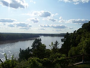
A relatively undeveloped reach o the river near Rocheport, Missouri
| |
| Name oreegin: The Missouri tribe, whose name in turn meant "fowk wi widden canoes"[1] | |
| Kintra | Unitit States |
|---|---|
| States | Montana, North Dakota, Sooth Dakota, Nebraska, Iowa, Kansas, Missouri |
| Tributaries | |
| - left | Jefferson, Dearborn, Sun, Marias, Milk, James, Big Sioux, Grand, Chariton |
| - right | Madison, Gallatin, Yellowstone, Little Missouri, Cheyenne, White, Niobrara, Platte, Kansas, Osage, Gasconade |
| Ceeties | Great Falls, MT, Bismarck, ND, Pierre, SD, Sioux City, IA, Omaha, NE, Kansas City, KS, Kansas City, MO, St. Louis, MO |
| Primar soorce | Hell Roaring Creek, a tributary o the Jefferson River |
| - location | near Brower's Spring, Montana |
| - elevation | 9,100 ft (2,774 m) |
| - coordinates | 44°32′31″N 111°27′53″W / 44.54194°N 111.46472°W [6][7] |
| Seicontar soorce | Firehole River, a tributary o the Madison River |
| - location | Madison Lake, Yellowstone Naitional Pairk, Wyoming |
| - elevation | 8,215 ft (2,504 m) |
| - coordinates | 44°20′55″N 110°51′53″W / 44.34861°N 110.86472°W [8] |
| Soorce confluence | Missouri Headwaters State Park |
| - location | Three Forks, Montana |
| - elevation | 4,042 ft (1,232 m) |
| - coordinates | 45°55′39″N 111°20′39″W / 45.92750°N 111.34417°W [1] |
| Mooth | Mississippi River |
| - location | Spanish Lake, near St. Louis, Missouri |
| - elevation | 404 ft (123 m) [1] |
| - coordinates | 38°48′49″N 90°07′11″W / 38.81361°N 90.11972°WCoordinates: 38°48′49″N 90°07′11″W / 38.81361°N 90.11972°W [1] |
| Lenth | 2,341 mi (3,767 km) [9] |
| Basin | 529,350 sq mi (1,371,010 km2) [10] |
| Discharge | for Hermann, MO; RM 97.9 (RKM 157.6) |
| - average | 87,520 cu ft/s (2,478 m3/s) [11] |
| - max | 750,000 cu ft/s (21,238 m3/s) [12] |
| - min | 602 cu ft/s (17 m3/s) [11] |
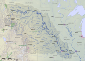
Map of the Missouri River and its tributaries in
North America | |
The Missouri River is the langest river in North Americae.[13]
References
[eedit | eedit soorce]- ↑ a b c d e "Missouri River". Geographic Names Information System. United States Geological Survey. 24 October 1980. Retrieved 6 Mey 2010.
- ↑ "Spotlight on the Big Muddy" (PDF). Missouri Stream Team. Archived frae the original (PDF) on 25 December 2018. Retrieved 14 Januar 2012.
- ↑ "AISRI Dictionary Database Search--prototype version. "River", Southband Pawnee". American Indian Studies Research Institute. Retrieved 26 Mey 2012.
- ↑ Karolevitz, Robert F.; Hunhoff, Bernie (1988). Uniquely South Dakota. Donning Company. p. 9. ISBN 978-0-89865-730-2.
- ↑ Ullrich, Jan, ed. (2011). New Lakota Dictionary (2nd ed.). Bloomington, IN: Lakota Language Consortium. ISBN 978-0-9761082-9-0. LCCN 2008922508.
- ↑ [1] USGS topographic map of the source
- ↑ Nell, Donald F.; Demetriades, Anthony. "The True Utmost Reaches of the Missouri: Were Lewis and Clark wrong when they identified the source of this great river?". Montana Outdoors (2005–07 to 08). Archived frae the original on 18 Januar 2012. Retrieved 14 Januar 2012.CS1 maint: uises authors parameter (link)
- ↑ "Madison Lake". Geographic Names Information System. United States Geological Survey. 4 Apryle 1980. Retrieved 21 Januar 2012.
- ↑ "Missouri River Environmental Assessment Program Summary". U.S. Geological Survey. Archived frae the original on 25 December 2018. Retrieved 8 October 2010.
- ↑ "The Missouri River Story". Columbia Environmental Research Center. U.S. Geological Survey. Archived frae the original on 27 Mey 2010. Retrieved 10 Apryle 2010.
- ↑ a b "USGS Gage #06934500 on the Missouri River at Hermann, Missouri: Water-Data Report 2009" (PDF). National Water Information System. U.S. Geological Survey. 1897–2009. Retrieved 24 August 2010.
- ↑ Pinter, Nicholas; Heine, Reuben A. "Hydrologic History of the Lower Missouri River". Geology Department. Southern Illinois University, Carbondale. Archived frae the original on 25 December 2018. Retrieved 8 Mey 2010.
- ↑ Howard Perlman, USGS (31 October 2012). "Lengths of major rivers, from USGS Water-Science School". Ga.water.usgs.gov. Archived frae the original on 5 Mairch 2009. Retrieved 21 November 2012.
Categeries:
- Missouri River
- Tributaries o the Mississippi River
- Borders o Iowa
- Borders o Kansas
- Borders o Missouri
- Borders o Nebraska
- Borders o Sooth Dakota
- Geografie o Omaha, Nebraska
- Laundforms o Yankton Coonty, Sooth Dakota
- Laundforms o Gallatin Coonty, Montana
- Laundforms o Broadwater Coonty, Montana
- Laundforms o Lewis an Clark Coonty, Montana
- Laundforms o Cascade Coonty, Montana
- Laundforms o McCone Coonty, Montana
- Laundforms o Roosevelt Coonty, Montana
- Rivers o Iowa
- Rivers o Kansas
- Rivers o Missouri
- Rivers o Montana
- Rivers o Nebraska
- Rivers o North Dakota
- Rivers o Sooth Dakota
- Watterways in Omaha, Nebraska


