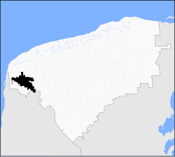
Maxcanú Municipality
Maxcanú | |
|---|---|
Municipality | |
 Location o Maxcanú in Yucatán | |
| Coordinates: 20°36′N 89°54′W / 20.600°N 89.900°WCoordinates: 20°36′N 89°54′W / 20.600°N 89.900°W | |
| Kintra | |
| State | |
| Govrenment | |
| • Municipal Preses | Fausto Jose Pereyra Carmona[1] |
| Area | |
| • Total | 1320.82 km2 (509.97 sq mi) |
| [1] | |
| Population | |
| • Total | 20,830 |
| Time zone | UTC-6 (Central Staundart Time) |
| • Summer (DST) | UTC-5 (Central Daylicht Time) |
| INEGI Code | 048 |
| Major Airport | Merida (Manuel Crescencio Rejón) Internaitional Airport |
| IATA Code | MID |
| ICAO Code | MMMD |
| Website | Nuestros municipios - Maxcanú |
Maxcanú is a municipality (municipio) in the wastren/soothwastren section o Mexican state o Yucatán. Its seat is the toun o Maxcanú. The municipality covers a aurie o approximately 1,321 km² an haes a total population o ower 18,800 inhabitants.
The municipality shares borders wi the follaein adjacent municipalities: Celestún, Samahíl, an Kinchil to the north, Chocholá, Kopomá, an Opichén tae the east, an Halachó tae the sooth. A smaw portion o its soothren border is shared wi the State o Campeche an aw.
Commonties
[eedit | eedit soorce]Those considered the mair important are, Chunchucmil, Kanach, Cochol, Paraiso, Santa Rosa an Santo Domingo. An the Haciendas o Simón, Xlam Riti, Crucero Copop, Ché, Canzote, Memu y Xamail. The minor touns in the municipality are: San Rafael, San Fernando, Granada, Chactún, Sombrilla, Chan Chocholá an Coahuilá.[1]
Landmarks
[eedit | eedit soorce]Airchaeological
[eedit | eedit soorce]A temple dedicatit tae Oor Lady o Munt Caramel that wis built in the seiventeent hunderyear an twa chapels, the first in honor o St. Michael the Airchangel an the seicont at the Three Crosses; an three umwhile haciendas Kochol cried Santo Domingo, Grenada an Santa Rosa.[1]
Prehispanic
[eedit | eedit soorce]Thare is an airchaeological steid locatit near Chunchucmil, bearin the same name.[1]
See an aw
[eedit | eedit soorce]Freemit airtins
[eedit | eedit soorce]- http://www.yucatan.gob.mx/estado/municipios/31048a.htm Archived 2007-02-26 at the Wayback Machine - Geographic, demographic, and historic information, in Spanish, about the Municipality of Maxcanú.
| Wikimedia Commons haes media relatit tae Maxcanú, Yucatán. |
References
[eedit | eedit soorce]- ↑ a b c d e "Nuestros municipios - Maxcanú". Archived frae the original on 26 Februar 2007. Retrieved 12 November 2009.
- ↑ "Encyclopedia of the Municipalities of Mexico: Yucatan". Archived frae the original on 20 November 2008. Retrieved 1 November 2009.
- ↑ Census Results by Locality, 2005 INEGI.

