Kota Bharu
Kota Bharu كوت بهارو | |
|---|---|
 Jalan Temenggong, Kota Bharu | |
| Coordinates: 6°8′0″N 102°15′0″E / 6.13333°N 102.25000°E | |
| Kintra | |
| State | |
| First settled | 1844 |
| Area | |
| • Total | 394 km2 (152 sq mi) |
| Population (2011) | |
| • Total | 491,237 [1] |
| • Density | 1247/km2 (3,230/sq mi) |
| Time zone | UTC+8 (MST) |
| • Summer (DST) | Nae observed |
| Area code(s) | 09 |
| Website | http://www.mpkb.gov.my/ |
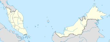
Kota Bharu (Jawi: كوت بهارو; occasionally referred tae as Kota Baharu) is a ceety in Malaysie that serves as the state caipital an ryal seat o Kelantan. It is the name o the territory (jajahan) in which Kota Bharu Ceety is situatit an aa. The name means 'new ceety' or 'new castle/fort' in Malay. Kota Bharu is situatit in the northeastren pairt o Peninsular Malaysie, an lies near the mooth o the Kelantan River at 6°8′N 102°15′E / 6.133°N 102.250°E. The northeastren Malaysie ceety is close tae the Thai border.
Kota Bharu is home tae mony mosques, various museums, the unique airchitectur o the auld ryal pailaces (still occupied bi the sultan an sultanah an off-leemits tae visitors but viewable frae ootside) an umwhile ryal biggins (which can be visitit) in the centre o toun.
The Ceety is served bi Keretapi Tanah Melayu's East Coast Line at the nearbi Wakaf Bharu Terminal Station, in the toun o Wakaf Bharu athort the Kelantan River tae Stesen Railway Station an Sultan Ismail Petra Airport, locatit in Pengkalan Chepa.

