Greenville, Ohio
Appearance
The "Scots" that wis uised in this airticle wis written bi a body that haesna a guid grip on the leid. Please mak this airticle mair better gin ye can. |
Greenville, Ohio | |
|---|---|
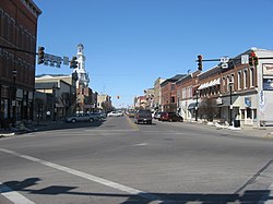
 Intersection o Washington, Martin an Broadway in Greenville | |
| Eik-name(s): "The Treaty City" | |
 Location in Darke Coonty an the state o Ohio. | |
| Coordinates: 40°6′9″N 84°37′41″W / 40.10250°N 84.62806°WCoordinates: 40°6′9″N 84°37′41″W / 40.10250°N 84.62806°W | |
| Kintra | Unitit States |
| State | Ohio |
| Coonty | Darke |
| Govrenment | |
| • Mayor | Michael Bowers |
| Area | |
| • Total | 17.25 km2 (6.66 sq mi) |
| • Laund | 17.09 km2 (6.60 sq mi) |
| • Water | 0.16 km2 (0.06 sq mi) |
| Elevation | 318 m (1043 ft) |
| Population | |
| • Total | 13,227 |
| • Estimate (2012[4]) | 13,105 |
| • Density | 773.8/km2 (2004.1/sq mi) |
| Time zone | UTC-5 (Eastren (EST)) |
| • Summer (DST) | UTC-4 (EDT) |
| ZIP code | 45331 |
| Area code(s) | 937 |
| FIPS code | 39-32340[5] |
| GNIS featur ID | 1064762[2] |
| Website | http://www.cityofgreenville.org/ |
Greenville is a ceety in an coonty seat[6] o Darke Coonty, Ohio, Unitit States. The population wis 13,227 at the 2010 census.
References
[eedit | eedit soorce]- ↑ Cite error: Invalid
<ref>tag; no text was provided for refs namedGazetteer files - ↑ a b "US Board on Geographic Names". United States Geological Survey. 25 October 2007. Retrieved 31 Januar 2008.
- ↑ Cite error: Invalid
<ref>tag; no text was provided for refs namedFactFinder - ↑ "Population Estimates". United States Census Bureau. Retrieved 17 Juin 2013.
- ↑ "American FactFinder". United States Census Bureau. Retrieved 31 Januar 2008.
- ↑ "Find a County". National Association of Counties. Retrieved 7 Juin 2011.
Freemit airtins
[eedit | eedit soorce]| Wikimedia Commons haes media relatit tae Greenville, Ohio. |
- City website
 . Encyclopædia Britannica (11th ed.). 1911. Cite has empty unkent parameters:
 |HIDE_PARAMETER15=,|HIDE_PARAMETER13=,|HIDE_PARAMETER14c=,|HIDE_PARAMETER14=,|HIDE_PARAMETER9=,|HIDE_PARAMETER3=,|HIDE_PARAMETER1=,|HIDE_PARAMETER4=,|HIDE_PARAMETER2=,|HIDE_PARAMETER8=,|HIDE_PARAMETER20=,|HIDE_PARAMETER5=,|HIDE_PARAMETER7=,|HIDE_PARAMETER10=,|separator=,|HIDE_PARAMETER14b=,|HIDE_PARAMETER6=,|HIDE_PARAMETER11=, and|HIDE_PARAMETER12=(help)
