Dunuin
Appearance
(Reguidit frae Dunoon)
Dunuin
| |
|---|---|
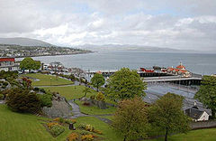
 Dunoon, leuking north frae Castle Hill towards Hunters Quay. The Victorian pier is tae the richt an the Queen's Hall is tae the left | |
Location within Argyll an Bute | |
| Population | 8,251 [2] (2001 census) est. 8,310[3] (2006), |
| OS grid reference | NS174764 |
| • Edinburgh | 82.1 mile (132.1 km) |
| • Lunnon | 434 mile (698 km) |
| Cooncil area | |
| Lieutenancy area | |
| Kintra | Scotland |
| Sovereign state | Unitit Kinrick |
| Post toun | DUNOON |
| Postcode destrict | PA23 |
| Diallin code | 01369 |
| Police | Scots |
| Fire | Scots |
| Ambulance | Scots |
| EU Pairlament | Scotland |
| UK Pairlament | |
| Scots Pairlament | |
Dunuin (Scots Gaelic: Dùn Omhain) is a toun situatit on the Cowal Peninsula in Argyll an Bute, Scotland. It sits on the Firth o Clyde tae the sooth o Holy Loch an tae the wast o Gourock.
References
[eedit | eedit soorce]- ↑ "Dunoon Scottish Gaelic". Allan171.pwp.blueyonder.co.uk. Archived frae the original on 17 October 2015. Retrieved 19 December 2012.
- ↑ "Comparative Population Profile: Dunoon Locality". Scotland's Census Results Online. 29 Apryle 2001. Archived frae the original on 19 Mey 2011. Retrieved 2 September 2008.
- ↑ "General Register Office for Scotland - Statistics - Publications and Data". Gro-scotland.gov.uk. 7 December 2009. Archived frae the original on 30 September 2008. Retrieved 31 Januar 2010.
| This Places o Scotland airticle is a stub. Ye can help Wikipaedia bi expandin it. |

