Cuzamá Municipality
Appearance
Cuzamá | |
|---|---|
Municipality | |
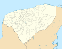
 Location o Cuzamá in Yucatán | |
Location o Cuzamá in Mexico | |
| Coordinates: 20°44′N 89°18′W / 20.733°N 89.300°WCoordinates: 20°44′N 89°18′W / 20.733°N 89.300°W | |
| Kintra | |
| State | |
| Municipal Seat | Cuzamá |
| Mexico Ind. | 1821 |
| Yucatán Est. | 1824 |
| Municipality Foondit | 1925 |
| Govrenment | |
| • Teep | |
| • Municipal Preses | Juan Bautista Kuk Pech[1] |
| Area | |
| • Total | 150.73 km2 (58.20 sq mi) |
| [1] | |
| Elevation | 17 m (56 ft) |
| Population | |
| • Total | 4,800 |
| • Density | 32/km2 (82/sq mi) |
| Time zone | UTC-6 (Central Staundart Time) |
| • Summer (DST) | UTC-5 (Central Daylicht Time) |
| INEGI Code | 015 |
| Major Airport | Merida (Manuel Crescencio Rejón) International Airport |
| IATA Code | MID |
| ICAO Code | MMMD |
| Website | Offeecial Wabsteid |
| Municipalities o Yucatan | |
The Municipality o Cuzamá is ane o the 106 municipalities in Yucatán state, Mexico. It is locatit in the east o the state an approximately 26 kilometers east o the ceety o Merida wi its municipal seat locatit in the Ceety o Cuzamá. The municipality borders tae the north the municipalities o Acanceh an Seye, tae the sooth, tae the sootheast Homun, an tae the west Tecoh.[1]
Commonties
[eedit | eedit soorce]The municipality is made up o 7 commonties as follaes:

| Community | Population[4] |
|---|---|
| Entire Municipality | 4,800 |
| Cuzamá | 3,577 |
| Eknakán | 659 |
| Chunkanán | 335 |
| Nohchakán | 175 |
| Chinkilá | 47 |
| Yaxkukul | 5 |
| San Eulogio | 2 |
References
[eedit | eedit soorce]- ↑ a b c "Nuestros municipios - XXX". Archived frae the original on 5 October 2009. Retrieved 12 November 2009.
- ↑ "Encyclopedia of the Municipalities of Mexico: Yucatan". Archived frae the original on 20 November 2008. Retrieved 1 November 2009.
- ↑ Census Results by Locality, 2005 INEGI.
- ↑ Census Population Results, 2005 INEGI.

