
Busturialdea
Busturialde - Urdaibai | |
|---|---|
 | |
| Kintra | |
| Autonomous commonty | Basque Kintra |
| Province | Biscay |
| Caipitals | Bermeo an Guernica |
| Municipalities | |
| Area | |
| • Total | 220 km2 (80 sq mi) |
| Population | |
| • Total | 46.000 |
| Time zone | UTC+1 (CET) |
| • Summer (DST) | UTC+2 (CEST) |
| Lairgest municipality | Bermeo (17.144) |
Busturialdea, namit Busturialde - Urdaibai an aw is a comarca o the province o Biscay, in the Basque Kintra, Spain. It is the heir o "Busturia", ane o the oreeginal merindades that uised tae compone the province o Biscay, which shoud no be ramfeeselt wi Busturia, which is a municipality locatit in this region. Busturialdea is a diminished portion o the same oreeginal subregion an haes twa caipital ceeties; Bermeo an Gernika-Lumo. It is ane o the seiven comarcas that compone the province o Biscay.
History[eedit | eedit soorce]
Busturia uised tae be ane o the merindades o Biscay an includit a lairger territory than the current ane o Busturialdea, as it reached the province o Gipuzkoa.
Busturialdea wis historically the core o Biscay: the caipitals o the province, Bermeo an Guernica, wur locatit in it; the veelage o Mundaka, belangin tae this region an aw, haed the privilege o speakin aye first in the sessions o its pairlament an for some time, the harbour o Bermeo wis the main portuar facility, tikl Bilbao wis foondit in 1300.
Busturialdea an its lush estuar wi important in prehistory an aw. Pairticularly significative is its steid o Santimamiñe cave, that yieldit a full sequence o human habitation frae Neanderthals tae the Airn Age, an bonnie Magdalenian cave pentins.
Geografie[eedit | eedit soorce]
Busturialdea is locatit at the north o the province o Biscay, limitin wi the comarcas o Lea-Artibai on the east, Uribe an Greater Bilbao on the wast an Durangaldea on the sooth. The Bay o Biscay leemits at north.
The comarca is locatit alang the Urdaibai estuar, which haes been namit Biosphere Reserve bi UNESCO in 1984[1][2]
Municipalities[eedit | eedit soorce]


| Municipality | Population | Territory km² | |
|---|---|---|---|
| Ajangiz | 457 | 7,35 | |
| Arratzu | 388 | 10,34 | |
| Bermeo | 17.144 | 34,12 | |
| Busturia | 1.745 | 19,63 | |
| Kortezubi | 423 | 11,91 | |
| Ea | 886 | 14,17 | |
| Elantxobe | 402 | 1,85 | |
| Ereño | 278 | 10,67 | |
| Errigoiti | 537 | 16,42 | |
| Forua | 969 | 7,94 | |
| Gautegiz Arteaga | 910 | 13,57 | |
| Gernika-Lumo | 16.812 | 8,47 | |
| Ibarrangelu | 641 | 15,56 | |
| Mendata | 378 | 22,39 | |
| Morga | 406 | 17,6 | |
| Muxika | 1.468 | 50,02 | |
| Mundaka | 1.940 | 4,15 | |
| Murueta | 302 | 5,45 | |
| Nabarniz | 227 | 11,75 | |
| Sukarrieta | 357 | 2,3 |
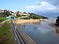
Photo Gallery[eedit | eedit soorce]
-
 San Pedro Atxarre
 -
-
-
-
 Madariaga Touer, Busturia
 -
 Childer camp, Sukarrieta
 -
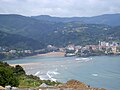
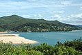
 Toña beach, Sukarrieta
 -
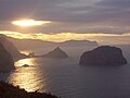
 Izaro isle
 -
 Laida beach, Ibarrangelu
 -

-
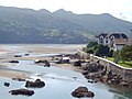
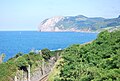 Ogoño cape
 -
 San Juan de Gaztelugatxe an Akats isle, Bermeo
 -
 San Juan de Gaztelugatxe, Bermeo
 -
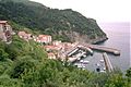
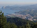
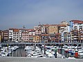 Port o Bermeo
 -
-

-
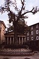 Tree o Gernika
 -
-
 Meetin hoose o Biscay, Gernika
 -
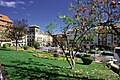
 Europe Pairk, Gernika
 -
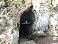 Santimamiñe cave, Kortezubi
 -
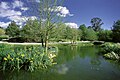
 Oma firth, Kortezubi


_-_El_ojo.JPG)
References[eedit | eedit soorce]
- ↑ Bizkaia maitea. Urdaibai Bizkaiko Foru Aldundia - Diputación Foral de Bizkaia
- ↑ Actividades en la Reserva de la Biosfera de Urdaibai UNESO Center of the Basque Country.