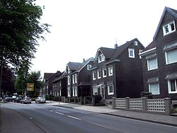
Burscheid
Burscheid | |
|---|---|
 | |
| Coordinates: 51°06′00″N 07°07′00″E / 51.10000°N 7.11667°ECoordinates: 51°06′00″N 07°07′00″E / 51.10000°N 7.11667°E | |
| Kintra | Germany |
| State | North Rhine-Westphalie |
| Admin. region | Köln |
| Destrict | Rheinisch-Bergischer Kreis |
| Subdivisions | 89 |
| Govrenment | |
| • Mayor | Stefan Caplan (CDU) |
| Area | |
| • Total | 27.38 km2 (10.57 sq mi) |
| Elevation | 88 - 251 m (−735 ft) |
| Population (2021-12-31)[1] | |
| • Total | 18,681 |
| • Density | 680/km2 (1,800/sq mi) |
| Time zone | CET/CEST (UTC+1/+2) |
| Postal codes | 51399 |
| Diallin codes | 02174 |
| Vehicle registration | GL |
| Website | www.burscheid.de |
Burscheid is a toun in the Rheinisch-Bergischer destrict, in North Rhine-Westphalie, Germany. The toun is kent for its sub-commonties (somewha equivalent tae the American concept o neebourheids) an the toun centre wi its mercatplace an kirks.
Economy
[eedit | eedit soorce]The twa lairgest employers in Burscheid are Federal Mogul GmbH (umwhile kent as Goetze AG) an Johnson Controls.
Govrenment
[eedit | eedit soorce]Hans Dieter Kahrl (CDU) wis first electit as Bürgermeister (mayor) in 1999. He wis reelectit in a general election on 26 September 2004 wi 51.6 % o the vote.
The current ceety cooncil wis electit wi the follaein brakdoun o poleetical affiliations (again, as o the 2004 general election):
- CDU, 2,932 votes, 40.0 % (1999: 47.4 %)
- SPD, 1,989 votes, 27.2 % (28.4 %)
- Grüne, 745 votes, 10.2 % (6.5 %)
- UWG, 884 votes, 12.1 % (8.5 %)
- FDP, 767 votes, 10.5 % (9.2 %)
Transportation
[eedit | eedit soorce]Burscheid is on the A1 Autobahn, an federal heich-gate (Bundesstraße) 51 travels throu the toun. The Verkehrsverbund Rhein-Sieg an Verkehrsverbund Rhein-Ruhr baith operate bus lines that stap in Burscheid.
Neebourin commonties
[eedit | eedit soorce]Burscheid is athin 15 kilometers o baith Solingen an Leverkusen.
Sub-commonties
[eedit | eedit soorce]Bellinghausen - Benninhausen - Berghamberg - Berringhausen - Blasberg - Dierath - Dünweg - Dürscheid - Großbruch - Großhamberg - Grünscheid - Heddinghofen - Hilgen - Kaltenherberg - Kämersheide - Kippekofen - Kleinhamberg - Kuckenberg - Lungstraße - Nagelsbaum - Oberlandscheid - Oberwietsche - Ösinghausen- Repinghofen - Rötzinghofen - Sträßchen.
Hilgen (or Burscheid-Hilgen) is the seicont lairgest an maist significant sub-commonty, next tae the main toun center (Burscheid itsel). Hilgen is on the toun's mairch wi Wermelskirchen an haes mony o its awn shops an restaurants. Maist sub-commonties in Burscheid are easily reachable bi fuit or bicycle.
Services
[eedit | eedit soorce]Burscheid haes its awn public schuils, soummin puil, polis force, an volunteer fire depairtment.
Tourist steids
[eedit | eedit soorce]- Haus Landscheid is a umwhile estate that belangit tae the knicht Heinrich von Nesselrode in 1731. It wis the steid o a restaurant frae 1983 tae 1998, but haes been abandoned syne 1998. Nae new uises o the property hae been planned or hae come forrit.
- The Lambertsmühle (Lamberts Mill) is in the Wiehbach valley in the soothwast o the toun, an haes been a museum syne 1994. The mill's main exhibit is entitled "The Path frae Grain tae Bread."
- The Paffenlöher Steffi (in the neebourin commonty o Paffenlöh) is a local dance club.
References
[eedit | eedit soorce]- ↑ "Bevölkerung der Gemeinden Nordrhein-Westfalens am 31. Dezember 2021" (in German). Landesbetrieb Information und Technik NRW. Retrieved 20 Juin 2022.
Freemit airtins
[eedit | eedit soorce]| Wikimedia Commons haes media relatit tae Burscheid. |
- Offeecial steid (in German)


