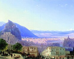
Auld Tbilisi


Auld Tbilisi (Georgie: ძველი თბილისი, dzveli t'bilisi) is a admeenistrative destrict (raioni) in Tbilisi, caipital o Georgie. Awtho the term "Auld Tbilisi" haes lang been uised tae denote a historical pairt o the ceety, it wis anerly in 2007 that it became a distinct admeenistrative entity tae incorporate several historical neebourheids umwhile includit in the destricts o Mtatsminda-Krtsanisi, Isani-Samgori, an Didube-Chughureti.
Auld Tbilisi is principally centred on wha is commonly referred tae as the Tbilisi Historic Destrict, which, due tae its significant airchitectural an urban value, as well as the threat tae its survival, wis previously leetit on the Warld Monuments Watch (1998, 2000, 2002).[1]
The destrict is locatit on the baith sides o the Mtkvari River an is dominatit bi Munt Mtatsminda, Narikala fortress an the Kartlis Deda monument. It chiefly represents a 19t-century urban fabric wi lairgely eclectic airchitectur which includes the biggins an structurs frae the 5t tae the 20t century. Housomeivver, maist o the pre-19t century ceety did no survive due tae the devastatin Persie invasion o 1795. The destrict hooses a bulk o the tourist attractions in Tbilisi, includin kirks, museums, sulphur bathhooses, an peculiar firthen hooses wi open, carvit balconies. In the 19t century, the core territory o the modren-day destrict o Auld Tbilisi wis tentatively subdividit intae ethnic neebourheids sic as Avlabari wi its Armenie an Georgie quairters, Alexanderdorf German quairter on the left bank o the Kura River an the Persie Quairter (Said-Abad) on the richt bank o the Mtkvari River.
New Life o Auld Tbilisi
[eedit | eedit soorce]In 2010, the govrenment o Tbilisi stairtit a program initiatit bi Mayor Gigi Ugulava. The idea wis tae renew auld an damagit hooses an cobbled streets tae mak Auld Tbilisi mair attractive for tourists an visitors.
References
[eedit | eedit soorce]- ↑ Sites previously listed on the World Monuments Watch Archived 2009-01-05 at the Wayback Machine. Warld Monuments Fund. Retrieved on May 25, 2007.
- Pickard, Robert (ed., 2001), Management of Historic Centres, pp. 93–112, 275–286. Taylor & Francis, ISBN 0-419-23290-7.
- Urban Rehabilitation Policy in Tbilisi (Georgia): Document. prep. bi the Technical Co-operation an Consultancy Unit, Directorate of Cultur an Cultural an Natural Heritage, Council of Europe Publishing, Strasbourg 2002, ISBN 92-871-4944-5.
Freemit airtins
[eedit | eedit soorce]| Wikimedia Commons haes media relatit tae Old Tbilisi. |
- Auld Tbilisi Offeecial Wabsteid Archived 2011-07-21 at the Wayback Machine
- (in Georgie) Auld Tbilisi Archived 2007-09-28 at the Wayback Machine. The Govrenment o Tbilisi.
- Tbilisi Project. Heritage an Modernity Association.
- Tbilisi History Museum. Archived 2007-06-28 at the Wayback Machine Georgian Airt Portal.
- Old Tbilisi (vintage photos) Archived 2007-07-22 at the Wayback Machine. Georgian Photographical Heritage Research Center.
- GWS offeecial wab page
- The Economist, A new look for Old Tbilisi,
Coordinates: 41°41′34″N 44°48′23″E / 41.69278°N 44.80639°E
