Anseba Region
Appearance
Anseba Zone Zoba Anseba | |
|---|---|
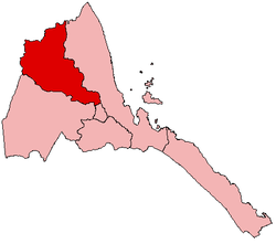
 Map o Eritrea wi the Anseba Region heichlichtit | |
| Kintra | Eritrea |
| Caipital | Keren |
| Govrenment | |
| • Admeenistrator | Selma Hassan |
| Area | |
| • Total | 23,200 km2 (9,000 sq mi) |
| Population | |
| • Total | 893,587 |
| • Density | 39/km2 (100/sq mi) |
Anseba (Tigrinya: ኣንሰባ) is an inland region o Eritrea, in the wast o the kintra.
Overview
[eedit | eedit soorce]Its capital is Keren an it has an area about 23,000 km². It is name after the Anseba River around which the region is situate. The river begins in the central Eritrean highland plateau, in the suburbs northwest o the capital Asmara. It then descends northwards into the northwest to the lowlands', travel to the mountains o Rora Habab an Sahel afore join in the Barka River near the border with Sudan. Other round in this region include Halhal. The region borders Gash-Barka to the sooth, the Central (Maekel) region to the sooth-east, the Northern Reid Sea Region to the east an north, an the nation o Sudan to the wast.
Destricts
[eedit | eedit soorce]The region includes the follaein destricts:
- Adi Tekelezan Destrict
- Asmat Destrict
- Elabered Destrict
- Geleb Destrict
- Hagaz Destrict
- Halhal Destrict
- Habero Destrict
- Keren Destrict
- Kerkebet Destrict
- Sela Destrict
Notes
[eedit | eedit soorce]References
[eedit | eedit soorce]| Wikimedia Commons haes media relatit tae Anseba Region. |
- Edward Denison and Edward Paice. 2007. Eritrea, fourth edition, Published by Bradt Travel Guides, 224 pages ISBN 1841621714, 9781841621715
- C. Michael Hogan. 2009. Painted Hunting Dog: Lycaon pictus, GlobalTwitcher.com, ed. N. Stromberg Archived 2010-12-09 at the Wayback Machine
- GeoHive global statistics Archived 2009-05-06 at the Wayback Machine
