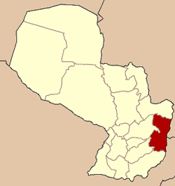
Alto Paraná Depairtment
- For the film, see Alto Paraná (film).
Alto Paraná Depairtment Departamento de Alto Paraná | |
|---|---|
 Alto Paraná shown in red | |
| Coordinates: 25°25′S 54°38′W / 25.417°S 54.633°W | |
| Kintra | |
| Region | Eastren Region |
| Established | 1945 |
| Caipital | Ciudad del Este |
| Lairgest ceety | Ciudad del Este |
| Govrenment | |
| • Govrenor | Nelson Aguinagalde (Naitional Republican Association) |
| Area | |
| • Total | 14895 km2 (5,751 sq mi) |
| Area rank | 7 |
| Population (2007)[1] | |
| • Total | 703,507 |
| • Rank | 2 |
| • Density | 47/km2 (120/sq mi) |
| Time zone | UTC-04 (AST) |
| • Summer (DST) | UTC-03 (ADT) |
| ISO 3166 code | PY-10 |
| Number o Destricts | 19 |
| Website | altoparana.gov.py |
Alto Paraná is a depairtment in Paraguay. The caipital is Ciudad del Este (umwhile kent as Puerto Presidente Stroessner, oreeginally Puerto Flor de Lis).
The Alto Paraná depairtment haes experiencit tremendous economic an population growthe in the past 50 years. Maist o this growthe haes been concentratit in the depairtment caipital o Ciudad del Este, an mainly occurred efter the construction o the Puente de la Amistad brig in 1961, which connects Paraguay an Brazil. This depairtment is hame tae the Itaipu pouer plant, which supplees 95% o the energy consumit bi Paraguay, an the Acaray Dam. Several ecological reserves, a zoo an the Taiwanese-Paraguayan Technology Pairk are situatit in this depairtment.
The ceety o Presidente Franco wis the first ceety foondit in this depairtment. Several important agricultural establishments are centred in the region o Minga Guazú which is hame o the Guarani Internaitional Airport.
Geography
[eedit | eedit soorce]Location
[eedit | eedit soorce]This depairtment is locatit in the Oriental Region o Paraguay, atween parallels 24° 30’ an 26° 15’ o latitude sooth an atween the meridians 54° 20’ an 55° 20’ o longitude wast.
It is locatit in the Center East o Oriental Region. It border wi:
- Tae the North: wi Canindeyú Depairtment
- Tae the Sooth: wi Itapúa Depairtment
- Tae the East: wi Brazil
- Tae the Wast: wi Caaguazú an Caazapá departments
The caipital is Ciudad del Este, oreeginally namit Puerto Flor de Lis, an later Puerto Presidente Stroessner till it receivit the name that haes nouadays ance the dictatorial govrenment o General Stroessner wis ower. This ceety leemits wi the Brazilian ceety, Foz de Yguazú.
Destricts
[eedit | eedit soorce]The depairtment is dividit intae 20 destricts:

| Distritos | Población (2002) |
|---|---|
| 1 Ciudad del Este | 222.274 |
| 2 Doctor Juan León Mallorquín | 16.243 |
| 3 Domingo Martínez de Irala | 6.734 |
| 4 Hernandarias | 63.248 |
| 5 Iruña | 4.710 |
| 6 Itakyry | 23.765 |
| 7 Juan Emilio O'Leary | 16.367 |
| 8 Los Cedrales | 9.003 |
| 9 Mbaracayú | 8.337 |
| 10 Minga Guazú | 48.006 |
| 11 Minga Porá | 11.180 |
| 12 Naranjal | 11.921 |
| 13 Ñacunday | 8.403 |
| 14 Presidente Franco | 52.826 |
| 15 San Alberto | 11.523 |
| 16 San Cristóbal | 7.670 |
| 17 Santa Fe del Paraná | ND |
| 18 Santa Rita | 16.427 |
| 19 Santa Rosa del Monday | 11.287 |
| 20 Yguazú | 8.748 |
Sister provinces
[eedit | eedit soorce]References
[eedit | eedit soorce]- ↑ http://www.dgeec.gov.py/Publicaciones/Biblioteca/Anuario2007/02.%20Poblaci%C3%B3n%20y%20Vivienda.pdf 2007 Statistic by the DGEEC.
Freemit airtins
[eedit | eedit soorce]- Alto Paraná Info (in Spainyie) Archived 2006-05-16 at the Wayback Machine

