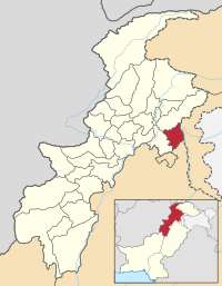
Abbottabad Destrict
Abottabad Destrict | |
|---|---|
 Map o Khyber Pakhtunkhwa wi Abbottabad Destrict heichlichtit | |
| Kintra | Pakistan |
| Province | Khyber Pakhtunkhwa |
| Caipital | Abbottabad |
| Area | |
| • Total | 1969 km2 (760 sq mi) |
| Population (1998) | |
| • Total | 880,666 |
| • Density | 448/km2 (1,160/sq mi) |
| Time zone | UTC+5 (PST) |
| Nummer o Union Cooncils | 51 |
| Nummer o Tehsils | 2 |
| Website | http://www.abbottabad.gov.pk |
Abbottabad (Urdu: ضلع ایبٹ آباد) is a destrict in the Khyber Pakhtunkhwa province o Pakistan. The destrict covers a aurie o 1,969 km wi the ceety o Abbottabad bein the principal toun.[1] Neebourin destricts are Mansehra tae the north, Muzaffarabad tae the east, Haripur tae the wast, an Rawalpindi tae the sooth.[2]
Subdiveesions[eedit | eedit soorce]

Abbottabad destrict is dividit intae twa tehsils, Abbottabad an Havelian as well as ane urban admeenistration aurie – Nawanshehr. Thare are fifty-ane Union Cooncils in the destrict, 35 in Abbottabad tehsil an 16 in Havelian.
References[eedit | eedit soorce]
- ↑ Geography of District Abbottabad Archived 2007-11-29 at the Wayback Machine
- ↑ Cite error: Invalid
<ref>tag; no text was provided for refs namedIUCN
Template:Destricts o Khyber Pakhtunkhwa Template:Abbottabad-Union-Cooncils
