Vänern
Appearance
| Loch Vänern | |
|---|---|
 frae Hjortens Udde | |
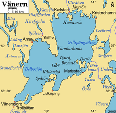
 Detail cairt o the loch wi surroondins | |
| Coordinates | 58°55′N 13°30′E / 58.917°N 13.500°ECoordinates: 58°55′N 13°30′E / 58.917°N 13.500°E |
| Primary inflows | Klarälven |
| Primar ootflows | Göta älv |
| Basin kintras | Swaden |
| 5,650 km²[1] | |
| Average deepth | 27 m[1] |
| Max. deepth | 106 m[1] |
| 153 km³[1] | |
| Surface elevation | 44 m[1] |
| Islands | Brommö, Djurö, Fågelö, Hammarö, Kållandsö, Lurö |
| References | [1] |

Loch Vänern (Swadish pronunciation: [ˈvɛːnəɳ]) is the maistmuckle loch in Swaden, the maistmuckle loch in the European Union an the third-maistmuckle loch in Europe efter Ladoga an Onega in Roushie. It is locatit in the provinces o Västergötland, Dalsland, an Värmland in the soothwast o the kintra.
History
[eedit | eedit soorce]The Battle on the Ice o Loch Vänern wis a 6t-century battle recordit in the Norse sagas an refert tae in the Auld Inglis epic Beowulf.
References
[eedit | eedit soorce]- ↑ a b c d e f Seppälä, Matti (2005), The Physical Geography of Fennoscandia, Oxford University Press, p. 145, ISBN 978-0-19-924590-1
Fremmit airtins
[eedit | eedit soorce]- Offeecial wabsteid
- Loch Vanern guide Archived 2007-06-25 at the Wayback Machine
- Väner museum i Lidköping Archived 2019-06-26 at the Wayback Machine (in Swadish)
| This Swaden-relatit airticle is a stub. Ye can help Wikipaedia bi expandin it. |
