Sukhothai Province
The "Scots" that wis uised in this airticle wis written bi a body that haesna a guid grip on the leid. Please mak this airticle mair better gin ye can. |

Sukhothai (Thai: สุโขทัย) is ane o the northren provinces (changwat) o Thailand. Neighborin provinces are Phrae, Uttaradit, Phitsanulok, Kamphaeng Phet, Tak, an Lampang. Sukhothai can be translatit as Dawn o Happiness.
Geography
[eedit | eedit soorce]Sukhothai is locatit in the valley o the Yom River on the lawer edge o the northren region, 427 kilometres north o Bangkok, an covers some 6,596 square kilometres.
The Khao Luang Muntain Range, wi its fower main peaks: Khao Phu Kha, Khao Phra Mae Ya, Khao Chedi, an Pha Narai, lies athin the Ramkhamhaeng Naitional Pairk in the sooth o the province.[1] The Si Satchanalai Naitional Pairk is locatit in the north-wast, protectin the muntainous forest auries o the province.
History
[eedit | eedit soorce]
Sukhothai, meanin the Dawn o Happiness, wis a toun foondit in the 13t century on the fringe o the Khmer empire. The exact year is unknown, but according to the Fine Arts Office it was atween 1238 an 1257. Foondit by Phokhun Si Intharathit, it wis the first truly independent Thai (Siamese) Kinrick efter defeatin the Khmers. Sukhothai enjoyed a gowden age unner their third king, King Ramkhamhaeng, who wis creditit wi creatin the Khmer-derived Thai alphabet which is essentially the same as that in uise the day.[2] He an aa laid the foondation for politics, the monarchy an releegion, as well as expandin its boondary o influence. Sukhothai wis later ruled bi mony kings. The province is maist famous for the historic ceety o Sukhothai, the caipital o the Sukhothai Kinrick. It is locatit aboot 12 km frae the modren New Sukhothai ceety. Not far frae Sukhothai are the Si Satchanalai Historical Pairk an the Kamphaeng Phet Historical Pairk. Baith wur ceeties athin the umwhile Sukhothai kinrick an o the same time period.
The province wis at first kent as Sawankhalok; it wis renamed tae Sukhothai in 1939.[3]
Seembols
[eedit | eedit soorce]The provincial seal shows King Ramkhamhaeng the Great sittin on the Managkhasila Asana throne. Unner King Ramkhamhaeng the kinrick o Sukhothai flourished the maist.
Provincial tree is Afzelia xylocarpa; provincial flower is the Lotus (Nymphaea lotus).
The provincial slogan is Source o naitional heritage, the Thai alphabets, the best Loy Krathong celebrations, firm foondation o Buddhism, the fine Teen Jok cloth, auncient chinaware, holy Pho Khun Ramkhamhaeng’s mither, dawn o happiness.
Admeenistrative diveesions
[eedit | eedit soorce]
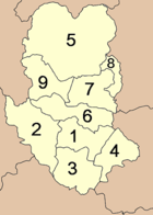
The province is subdividit intae nine destricts (amphoe). These are further subdividit intae 86 communes (tambon) an 782 veelages (muban).
References
[eedit | eedit soorce]- ↑ Ramkhamhaeng National Park
- ↑ "Sukhothai". Tourthai.net. 2006. Archived frae the original on 11 October 2007. Retrieved 28 September 2008.
- ↑ "พระราชกฤษฎีกาเปลี่ยนนามจังหวัดและอำเภอบางแห่ง พุทธศักราช ๒๔๘๒" (PDF). Royal Gazette (in Thai). 56 (0 ก): 351–353. 17 Apryle 1939. Archived frae the original (PDF) on 9 Apryle 2008. Retrieved 4 Februar 2011.
| Wikimedia Commons haes media relatit tae Sukhothai. |
