Moont Kenyae
Appearance
(Reguidit frae Munt Kenyae)
The "Scots" that wis uised in this airticle wis written bi a body that haesna a guid grip on the leid. Please mak this airticle mair better gin ye can. (September 2020) |
| Moont Kenyae | |
|---|---|
 Moont Kenyae | |
| Heichest pynt | |
| Elevation | 5,199 m (17,057 ft) [1] |
| Prominence | 3,825 m (12,549 ft) [1] Ranked 32nd |
| Isolation | 323 kilometre (201 mi) |
| Leetin | Seiven Seicont Summits Kintra heich pynt Ultra |
| Coordinates | 0°9′03″S 37°18′27″E / 0.15083°S 37.30750°ECoordinates: 0°9′03″S 37°18′27″E / 0.15083°S 37.30750°E [1] |
| Geografie | |
| Topo map | Mt Kenya bi Wielochowski an Savage[2][3] |
| Geology | |
| Muntain teep | Stratovolcano (extinct) |
| Last eruption | 2.6–3.1 MYA |
| Climbing | |
| First ascent | 1899 by Halford Mackinder, wi guides César Ollier an Joseph Brocherel |
| Easiest route | Rock climb |
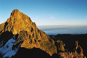
Moont Kenyae is the heichest muntain in Kenyae an the seicont-heichest in Africae, efter Kilimanjaro.[4]
References
[eedit | eedit soorce]- ↑ a b c "Africa Ultra-Prominences" Peaklist.org. Retrieved 2012-02-06.
- ↑ "Mount Kenya Map Sample". Ewpnet.com. Retrieved 16 Apryle 2010.
- ↑ Mount Kenya Map and Guide (Map) (4th ed.). 1:50,000 with 1:25,000 inset. EWP Map Guides. Cartografie bi EWP. EWP. 2007. ISBN 978-0-906227-96-1.
- ↑ Rough Guide Map Kenya (Map) (9 ed.). 1:900,000. Rough Guide Map. Cartografie bi World Mapping Project. Rough Guide. 2006. ISBN 1-84353-359-6.
| This airticle is a stub. Ye can help Wikipaedia bi expandin it. |

