Loch Lomond an The Trossachs Naitional Pairk
Appearance
(Reguidit frae Loch Lomond an the Trossachs Naitional Pairk)
| Loch Lomond an The Trossachs Naitional Pairk | |
|---|---|
IUCN category V (pertectit landscape/seascape) | |
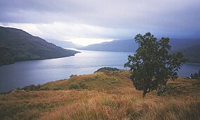
 Leukin eastwards alang Loch Katrine | |
| Location | Scotland, Argyll an Bute, Pairth an Kinross, Stirling an Wast Dunbartonshire |
| Coordinates | 56°15′N 4°37′W / 56.250°N 4.617°WCoordinates: 56°15′N 4°37′W / 56.250°N 4.617°W |
| Area | 1,865 km² (720 sq mi) |
| Established | 2002 |
| Govrenin body | National Park Authority |
Loch Lomond an The Trossachs Naitional Pairk (Scots Gaelic: Pàirc Nàiseanta Loch Laomainn is nan Tròisichean) is a naitional pairk in Scotland centred on Loch Lomond, an includes several ranges o hills an the Trossachs.
| This Places o Scotland airticle is a stub. Ye can help Wikipaedia bi expandin it. |

