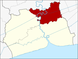
Krathum Baen Destrict
Krathum Baen กระทุ่มแบน | |
|---|---|
 Amphoe location in Samut Sakhon Province | |
| Coordinates: 13°39′21″N 100°16′4″E / 13.65583°N 100.26778°ECoordinates: 13°39′21″N 100°16′4″E / 13.65583°N 100.26778°E | |
| Kintra | |
| Province | Samut Sakhon |
| Seat | Krathum Baen |
| Area | |
| • Total | 135.276 km2 (52.230 sq mi) |
| Population (2005) | |
| • Total | 138,309 |
| • Density | 1022/km2 (2,650/sq mi) |
| Time zone | UTC+7 (THA) |
| Postal code | 74110 |
| Geocode | 7402 |
Krathum Baen (Thai: กระทุ่มแบน) is a destrict (Amphoe) in the northren pairt o Samut Sakhon Province, central Thailand.
History
[eedit | eedit soorce]Krathum Baen aurie wis a pairt o Mueang Samut Sakhon Destrict. It wis creatit in 1900. In 1926 the govrenment addit Tambon Tha Mai, Bang Yang, Nong Kok Khai an Om Noi o Sam Phran Destrict, Nakhon Pathom Province tae the destrict.
Geografie
[eedit | eedit soorce]Neebourin destricts are (frae the north clockwise) Sam Phran Destrict o Nakhon Pathom Province, Nong Khaem an Bang Bon o Bangkok, Mueang Samut Sakhon an Ban Phaeo o Samut Sakhon Province.
The important watter resoorce are the Tha Chin river an Phasi Charoen canal.
Admeenistration
[eedit | eedit soorce]The destrict is subdividit intae 10 subdestricts (tambon), which are further subdividit intae 76 veelages (muban). Thare is a ceety (thesaban nakhon) - Om Noi. An a toun (thesaban mueang) - Krathum Baen. The nan-municipal aurie is admeenistrated bi 8 Tambon admeenistrative organisations (TAO).

