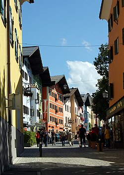
Kitzbühel
Appearance
Kitzbühel | |
|---|---|
 Kitzbühel in mid-August 2008 | |
| Coordinates: 47°26′47″N 12°23′31″E / 47.44639°N 12.39194°ECoordinates: 47°26′47″N 12°23′31″E / 47.44639°N 12.39194°E | |
| Kintra | Austrick |
| State | Tyrol |
| Destrict | Kitzbühel |
| Govrenment | |
| • Mayor | Klaus Winkler (ÖVP) |
| Area | |
| • Total | 58.01 km2 (22.40 sq mi) |
| Elevation | 762 m (2,500 ft) |
| Population (2018-01-01)[2] | |
| • Total | 8,272 |
| • Density | 140/km2 (370/sq mi) |
| Time zone | UTC+1 (CET) |
| • Summer (DST) | UTC+2 (CEST) |
| Postal code | 6370 |
| Aurie code | 05356 |
| Vehicle registration | KB |
| Website | Kitzbühel |
Kitzbühel (pronoonced 'kɪtsbyːl) is a smaa medieval toun in Tyrol, Austrick an the admeenistrative centre o the Kitzbühel destrict (Bezirk). It haes a population o 8,204 (as o 1 Januar 2010).
The toun is situatit in the Kitzbühel Alps aboot 100 kilometre (62 mi) east o the state caipital o Innsbruck. It is a ski resort o internaitional renown.
References
[eedit | eedit soorce]- ↑ "Dauersiedlungsraum der Gemeinden Politischen Bezirke und Bundesländer - Gebietsstand 1.1.2018". Retrieved 10 Mairch 2019.
- ↑ "Einwohnerzahl 1.1.2018 nach Gemeinden mit Status, Gebietsstand 1.1.2018". Retrieved 9 Mairch 2019.


