
File:Iran relief location map.jpg

Size o this luikower: 672 × 600 pixels. Ither resolutions: 269 × 240 pixels | 538 × 480 pixels | 861 × 768 pixels | 1,200 × 1,071 pixels.
Oreeginal file (1,200 × 1,071 pixels, file size: 941 KB, MIME type: image/jpeg)
Ootline
| Descreeption |
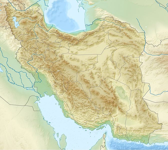
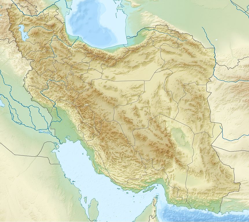
English: Location map of Iran.
Equirectangular projection. Strechted by 118.0%. Geographic limits of the map: * N: 40.0° N * S: 24.5° N * W: 43.5° E * E: 64.0° EMade with Natural Earth. Free vector and raster map data @ naturalearthdata.com. Deutsch: Topografische Karte des Iranischen Hochlandes mit der Verbindung zu Kleinasien im Westen und zum Hindukusch und Himalaya im Osten.
English: Topographic map of the Iranian plateau in Central Asia, connecting to Anatolia in the west and Hindu Kush and Himalaya in the east.
Español: Mapa topográfico de la Meseta iraní. Mapa topográfico de la meseta iraní que enlaza Anatolia en el oeste con el Hindu Kush y el Himalaya en el Este.
Euskara: Irango goi-ordokiaren mapa topografikoa, Anatolia mendebaldean eta Hindu Kush eta Himalaia ekialdean.
فارسی: فلات ایران سرزمین مرتفعی است در همسایگی مناطق کم ارتفاع غرب، شمال و جنوب آسیا.
Français : Carte du plateau iranien en Asie, lié à l'Anatolie à l'ouest, et à l'Hindu Kush et à l'Himalaya à l'est.
한국어: 이란 고원의 서쪽으로는 아나톨리아로 연결되고, 동쪽으로는 힌두쿠시 산맥와 히말라야 산맥과 연결된다.
Nederlands: Kaart van het Hoogland van Iran in Azië, dat zich uitstrekt van Anatolië in het westen tot aan de Hindoekoesj en de Himalaya in het oosten.
Norsk bokmål: Topografisk kart over det iranske høylandet, som grenser til Anatolia i vest og Hindu Kush og Himalaya i øst.
پنجابی: سطح مرتفع ایران دا نقشہ ، لہندے چ اناطولیا تے چڑھدے چ کوہ ہندوکش تے ہمالیہ نال جڑئیا.
Português: Mapa topográfico do planalto iraniano ligando a Anatólia a oeste e o Hindu Kush e os Himalaias a este.
Русский: Иранское нагорье располагается между Аравийским полуостровом на западе и севером Индийского субконтинента на востоке.
Türkçe: Batıda Anadolu'ya doğuda ise Hindukuş ve Himalaya dağlarına bağlanan İran platosunun topografik haritası.
اردو: سطع مرتفع ایران کا نقشہ، مغرب میں اناطولیہ اور مشرق میں ہندوکش اور ہمالیہ سے منسلک.
Tiếng Việt: Bản đồ địa hình với sơn nguyên Iran nối Anatolia ở phía tây với Hindu Kush và Himalaya ở phía đông.
中文:伊朗高原地形圖,連接安納托利亞西部,東與喜馬拉雅山相鄰. |
| Date | |
| Soorce | Ain wirk |
| Author | Uwe Dedering |
| Other versions |
|


Licensin
I, the copyright holder of this work, hereby publish it under the following licenses:
This file is licensed unner the Creative Commons Attribution-Share Alike 3.0 Unported license.
- Ye are free:
- tae share – tae copy, distribute an transmit the wirk
- tae remix – tae adapt the wirk
- Unner the follaein condeetions:
- attribution – Ye must attribute the wirk in the manner specified bi the author or licensor (but nae in ony way that suggests that thay endorse ye or yer uise o the wirk).
- share alik – If ye alter, transform, or big upon this wirk, ye mey distribute the resultin wirk anly unner the same or seemilar license tae this ane.

|
Permission is grantit tae copy, distribute an/or modify this document unner the terms o the GNU Free Documentation License, Version 1.2 or ony later version published bi the Free Software Foundation; wi no Invariant Sections, no Front-Cover Texts, an no Back-Cover Texts. A copy o the license is includit in the section enteetled GNU Free Documentation License. |
Ye mey select the license o yer choice.
File history
Clap oan ae date/time fer tae see the file aes it kithed at that time.
| Date/Time | Thummnail | Dimensions | Uiser | Comment | |
|---|---|---|---|---|---|
| current | 20:09, 11 Julie 2010 | | 1,200 × 1,071 (941 KB) | Uwe Dedering | 31. province Alborz |
| 15:51, 23 Apryle 2010 |  | 1,200 × 1,071 (941 KB) | Uwe Dedering | {{Information |Description={{en|1=Location map of Iran. Equirectangular projection. Strechted by 118.0%. Geographic limits of the map: * N: 40.0° N * S: 24.5° N * W: 43.5° E * E: 64.0° E Made with Natural Earth. Free vector and raster map data @ |
Eimage airtins
The follaein pages airts tae this image:
Global file uisage
The follaein ither wikis uise this file:
- Uisage on als.wikipedia.org
- Uisage on ar.wikipedia.org
- Uisage on ary.wikipedia.org
- Uisage on ast.wikipedia.org
- Uisage on av.wikipedia.org
- Uisage on azb.wikipedia.org
- Uisage on az.wikipedia.org
View mair global usage o this file.