
File:Caucasus topo map-blank.svg

Size of this PNG preview of this SVG file: 771 × 599 pixels. Ither resolutions: 309 × 240 pixels | 618 × 480 pixels | 988 × 768 pixels | 1,280 × 995 pixels | 2,560 × 1,990 pixels | 1,155 × 898 pixels.
Oreeginal file (SVG file, nominallie 1,155 × 898 pixels, file size: 4.43 MB)
Ootline
| Descreeption |
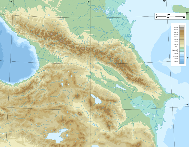
Deutsch: Topographische Karte von Kaukasien, französische Version English: Topographic map in French of Caucasus Français : Carte topographique en français du Caucase |
| Date | |
| Soorce |
English: Own work ; Topographic data from the NASA Shuttle Radar Topography Mission (SRTM3 v.2) (public domain) edited with 3DEM, reprojected in UTM with GDAL (GDAL), and vectorized with Inkscape ; UTM projection ; WGS84 datum ; shaded relief (composite image of N-W, W and N lightning positions) ; Reference used for the additional data : * Rivers, bathymetry : Demis add-on for World Wind (see the approval e-mail and the Demis forum) ; * coast : World data bank II ; Approximate scale of topographic data : 1:1,463,000 ; Note : The shaded relief is a raster image embedded in the SVG file. Français : Création personnelle ; Données topographiques de la NASA Shuttle Radar Topography Mission (SRTM3 v.2) (domaine public) éditées avec 3DEM, reprojetées en UTM avec GDAL et vectorisées avec Inkscape ; projection UTM ; WGS84 datum ; relief ombré (image composite d'éclairages du N-O, O et N) ; Références utilisées pour les données complémentaires : * Rivières, bathymétrie : Demis add-on for World Wind (cf. l'e-mail d'approbation de Demis et le Demis forum) ; * côtes : World data bank II ; Échelle approximative des données topographiques : 1:1 463 000 ; Note : Le relief ombré est une image bitmap embarquée dans le fichier SVG. Approximate geographic limits of the map (3' close) : * SW corner : 38°05'00"N – 39°33'00"E * SE corner : 38°05'00"N – 51°00'00"E * NE corner : 45°00'00"N – 51°00'00"E * NW corner : 45°00'00"N – 39°00'00"E |
| Author | Bourrichon - fr:Bourrichon) |
| Permission (Reuisin this file) |
GFDL / Attribution and Share-Alike required |
| Other versions |
|


|
This SVG file contains embedded text that can be translated into your language, using any capable SVG editor, text editor or the SVG Translate tool. For more information see: About translating SVG files. |
Licensin
I, the copyright holder of this work, hereby publish it under the following licenses:

|
Permission is grantit tae copy, distribute an/or modify this document unner the terms o the GNU Free Documentation License, Version 1.2 or ony later version published bi the Free Software Foundation; wi no Invariant Sections, no Front-Cover Texts, an no Back-Cover Texts. A copy o the license is includit in the section enteetled GNU Free Documentation License. |
This file is licensed under the Creative Commons Attribution-Share Alike 4.0 International, 3.0 Unported, 2.5 Generic, 2.0 Generic and 1.0 Generic license.
- Ye are free:
- tae share – tae copy, distribute an transmit the wirk
- tae remix – tae adapt the wirk
- Unner the follaein condeetions:
- attribution – Ye must attribute the wirk in the manner specified bi the author or licensor (but nae in ony way that suggests that thay endorse ye or yer uise o the wirk).
- share alik – If ye alter, transform, or big upon this wirk, ye mey distribute the resultin wirk anly unner the same or seemilar license tae this ane.
Ye mey select the license o yer choice.
File history
Clap oan ae date/time fer tae see the file aes it kithed at that time.
| Date/Time | Thummnail | Dimensions | Uiser | Comment | |
|---|---|---|---|---|---|
| current | 17:16, 9 November 2008 | | 1,155 × 898 (4.43 MB) | Bourrichon | |
| 15:59, 8 November 2008 |  | 1,155 × 898 (4.43 MB) | Bourrichon | == Summary == {{Information |Description={{de|Topographische Karte von Kaukasien, französische Version}}{{en|Topographic map in French of Caucasus}}{{fr|Carte topographique en français du Caucase}} |Sou |
Eimage airtins
The follaein pages airts tae this image:
Global file uisage
The follaein ither wikis uise this file:
- Uisage on ar.wikipedia.org
- Uisage on ast.wikipedia.org
- Uisage on av.wikipedia.org
- Uisage on az.wikipedia.org
- Azərbaycan dili
- Muğan düzü
- Araz
- Böyük Qafqaz
- Kür
- Göygöl (göl)
- Bazardüzü
- Şablon:Çay
- Ağrı dağı
- Qarayazı Dövlət Təbiət Qoruğu
- Göygöl Dövlət Təbiət Qoruğu
- İlisu Dövlət Təbiət Qoruğu
- Mingəçevir su anbarı
- Hacıqabul gölü
- Türyançay Dövlət Təbiət Qoruğu
- Talış dağları
- Kürəkçay
- Qabırrıçay
- Qanıxçay
- Sumqayıtçay
- İlandağ
- Göyçə gölü
- Göyəzən dağı
- Şablon:Yer xəritəsi
- Şablon:Yer xəritəsi/doc
- Şablon:Yer xəritəsi+
- Xınalıq dağı
- Qafqaz dağları
- Murovdağ
- Kəpəz dağı
- Sarısu gölü
- Böyükşor gölü
- Maralgöl
- Şablon:Su anbarı
- Şablon:Su anbarı/doc
- Candargöl
- Kazbek dağı
- Şirvan düzü
- Mil düzü
- Batabat gölü
- Beşbarmaq dağı
- Babazənən yüksəkliyi
View mair global usage o this file.