
File:Americas (orthographic projection).svg

Size of this PNG preview of this SVG file: 550 × 550 pixels. Ither resolutions: 240 × 240 pixels | 480 × 480 pixels | 768 × 768 pixels | 1,024 × 1,024 pixels | 2,048 × 2,048 pixels.
Oreeginal file (SVG file, nominallie 550 × 550 pixels, file size: 332 KB)
Ootline
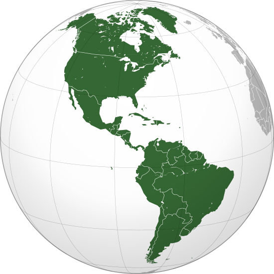
| Descreeption | Orthographic map of the Americas with national borders added |
| Date | |
| Soorce | Ain wirk |
| Author | Martin23230 |
| Other versions |
.svg) |
| SVG genesis |
.svg)
.svg)
.svg)
.svg)
.svg)
.svg)
.svg)
.svg)
.svg)
.svg)
.svg)
.svg)
.svg)
.svg)
.svg)
.svg)
.svg)
.svg)
.svg)
.svg)
.svg)
.svg)
.svg)
.svg)
.svg)
.svg)
.svg)
.svg)
.svg)
.svg)
.svg)
.svg)
.svg)
.svg)
.svg)
.svg)
.svg)
.svg)
.svg)
.svg)
.svg)
.svg)
.svg)
.svg)
.svg)
.svg)
.svg)
.svg)
.svg)
.svg)
.svg)
.svg)
.svg)
.svg)
.svg)
.svg)
.svg)
.svg)
.svg)
.svg)
.svg)
.svg)
.svg)
.svg)
.svg)
.svg)
.svg)
.svg)
.svg)
.svg)
.svg)
.svg)
.svg)

.svg)

.svg)

.svg)
.svg)
.svg)
.svg)
.svg)
.svg)
.svg)


.svg)
.svg)
.svg)
.svg)
.svg)
.svg)
.svg)

.svg)
.svg)
.svg)
.svg)
.svg)
.svg)
.svg)
.svg)
.svg)
.svg)

.svg)
.svg)
.svg)
.svg)
.svg)
.svg)
.svg)
_without_national_boundaries.svg)
.svg)
.svg)
.svg)
.svg)
.svg)
.svg)

.svg)
.svg)
.png)
.svg)
.svg)
.svg)
.svg)

.svg)
.svg)
.svg)
.svg)
.svg)
.svg)
.svg)
.svg)
.svg)
.svg)
.svg)

.svg)
.svg)
.svg)
.svg)
.svg)
.svg)
.svg)
.svg)
.svg)

.svg)
.svg)

.svg)
.svg)
.svg)
.svg)
.svg)
.svg)
.svg)
.svg)
.svg)
.svg)
.svg)
.svg)
.svg)
.svg)
.svg)
.svg)
.svg)
.svg)
.svg)
.svg)
.svg)
.svg)
.svg)
.svg)
.svg)
.svg)
.svg)
_-_Crimea_disputed.svg)
.svg)
.svg)
.svg)
.svg)
.svg)
.svg)
.svg)
.svg)
.svg)
.svg)
.svg)
_political.svg)
.svg)
.svg)
.svg)
.svg)
_-_Crimea_disputed_-_no_borders.svg)
.svg)
.svg)
.svg)
.svg)
.svg)
.svg)
.svg)
.svg)
.svg)
.svg)
.svg)

.svg)
.svg)
.svg)

.png)
.svg)
.svg)
.svg)
.svg)
.svg)
.svg)
.svg)
.svg)
.svg)
.svg)
.svg)
.svg)
.svg)
.svg)
.svg)
.svg)
.svg)
.svg)
.svg)
.svg)
.svg)
.svg)
.svg)
.svg)
.svg)
.svg)
.svg)
.svg)
.svg)
.svg)
.svg)
.svg)
.svg)
.svg)
.png)
.svg)
.svg)
.svg)
_(orthographic_projection).png)
.svg)
Licensin
I, the copyright holder of this work, hereby publish it under the following licenses:
This file is licensed unner the Creative Commons Attribution-Share Alike 3.0 Unported license.
- Ye are free:
- tae share – tae copy, distribute an transmit the wirk
- tae remix – tae adapt the wirk
- Unner the follaein condeetions:
- attribution – Ye must attribute the wirk in the manner specified bi the author or licensor (but nae in ony way that suggests that thay endorse ye or yer uise o the wirk).
- share alik – If ye alter, transform, or big upon this wirk, ye mey distribute the resultin wirk anly unner the same or seemilar license tae this ane.

|
Permission is grantit tae copy, distribute an/or modify this document unner the terms o the GNU Free Documentation License, Version 1.2 or ony later version published bi the Free Software Foundation; wi no Invariant Sections, no Front-Cover Texts, an no Back-Cover Texts. A copy o the license is includit in the section enteetled GNU Free Documentation License. |
Ye mey select the license o yer choice.
File history
Clap oan ae date/time fer tae see the file aes it kithed at that time.
| Date/Time | Thummnail | Dimensions | Uiser | Comment | |
|---|---|---|---|---|---|
| current | 22:24, 18 Julie 2016 | | 550 × 550 (332 KB) | Turnless | Reverted to version as of 04:48, 5 December 2009 (UTC) Hawaii is in Oceania |
| 02:05, 30 Apryle 2013 |  | 550 × 550 (1.44 MB) | Giggette | Centered | |
| 04:48, 5 December 2009 |  | 550 × 550 (332 KB) | Keepscases | borders | |
| 11:26, 16 August 2009 |  | 541 × 541 (332 KB) | Bosonic dressing | tweak map: colour St. Lawrence Island (Alaska, USA), draw in missing peripheral latitudinal lines | |
| 16:20, 26 Juin 2009 |  | 541 × 541 (318 KB) | Martin23230 | {{Information |Description= Orthographic map of the Americas |Source=self-made |Date=2009-06-26 |Author= Martin23230 |Permission= |other_versions= }} Category:Orthographic projections Category:Maps of the Americas |
Eimage airtins
The follaein pages airts tae this image:
Global file uisage
The follaein ither wikis uise this file:
- Uisage on ab.wikipedia.org
- Uisage on af.wikipedia.org
- Uisage on am.wikipedia.org
- Uisage on an.wikipedia.org
- Uisage on ar.wikipedia.org
- الولايات المتحدة
- عالم غربي
- هندوراس
- فنزويلا
- شعراء المهجر
- آسيا
- أوروبا
- قارة
- تصنيف:قارات
- البرازيل
- المكسيك
- كندا
- الأرجنتين
- تصنيف:كوبا
- تصنيف:أمريكا الشمالية
- سيمون بوليفار
- برمودا
- تصنيف:أمريكا الجنوبية
- تصنيف:أرجنتينيون
- المحيط الهادئ
- أستراليا
- القارة القطبية الجنوبية
- كوبا
- بليز
- تصنيف:دول أمريكا
- تصنيف:مدن أمريكية
- اللغة الإسبانية
- تصنيف:دول الكاريبي
- أوقيانوسيا
- تصنيف:أنهار أمريكا الجنوبية
- بوليفيا
- بيرو
View mair global usage o this file.
.svg)
.svg)