Dunedin
Appearance
Dunedin Ōtepoti (Māori) | |
|---|---|
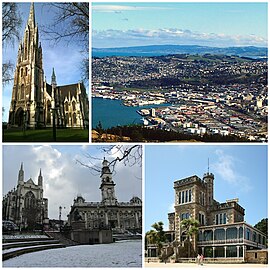
 Clockwise frae top: First Kirk o Otago, cityscape seen frae Signal Hill leukoot, Larnach Castle, Anglican Cathedral an Toun Haw on The Octagon | |
| Eik-name(s): | |
| Coordinates: 45°52′S 170°30′E / 45.867°S 170.500°E | |
| Kintra | New Zealand |
| Region | Otago |
| Territorial authority | Dunedin Ceety Cooncil |
| Settled bi Māori | c. 1300[3] |
| Settled bi Europeans | 1848 |
| Incorporated[4] | 1855 |
| Named for | Dùn Èideann – Scots Gaelic name for Edinburgh |
| Electorates | Dunedin North Dunedin Sooth |
| Govrenment | |
| • Mayor | Dave Cull |
| • Deputy Mayor | Chris Staynes |
| Area | |
| • Territorial | 3314 km2 (1,280 sq mi) |
| • Urban | 255 km2 (98 sq mi) |
| Population (June 2018)[6] | |
| • Territorial | 130,500 |
| • Density | 39/km2 (100/sq mi) |
| • Urban | 122,000 |
| • Urban density | 480/km2 (1,200/sq mi) |
| Demonym(s) | Dunedinite |
| Time zone | UTC+12 (NZST) |
| • Summer (DST) | UTC+13 (NZDT) |
| Postcode | 9010, 9011, 9012, 9013, 9014, 9016, 9018, 9022, 9023, 9024, 9035, 9076, 9077, 9081, 9082, 9092 |
| Area code(s) | 03 |
| Local iwi | Ngāi Tahu |
| Website | www.DunedinNZ.com |
Dunedin, (kent in the Māori leid as Otepoti) is the fift maistmuckle city o New Zealand wi mair nor 142,000 indwallers. It is situatit in the sooth-east o the Sooth Isle.
The city haes haed the mucklest population o Scots in the kintra, syne aboot the 1860s. Thare are evidents that a lanerly byleid o the Scots leid wis spakken in the airt, bit hit haes dee'd oot.[7]
References
[eedit | eedit soorce]- ↑ "Southern style". Stuff.co.nz. 19 Mairch 2009. Retrieved 15 Mairch 2011.
- ↑ "Supersport's Good Week / Bad Week: An unhappy spectator". The New Zealand Herald. 1 Mey 2009. Retrieved 18 September 2009.
- ↑ Irwin, Geoff; Walrond, Carl (4 Mairch 2009). "When was New Zealand first settled? – The date debate". Te Ara: The Encyclopedia of New Zealand. Retrieved 14 Februar 2010.
- ↑ Dunedin Town Board
- ↑ "Mayor Dave Cull". Dunedin City Council. Archived frae the original on 23 September 2015. Retrieved 14 Februar 2015.
- ↑ "Subnational Population Estimates: At 30 June 2019". Statistics New Zealand. 22 October 2019. Retrieved 11 Januar 2020. For urban areas, "Subnational population estimates (UA, AU), by age and sex, at 30 June 1996, 2001, 2006–18 (2017 boundaries)". Statistics New Zealand. 23 October 2018. Retrieved 23 October 2018.
- ↑ "Indo-European phylosector by the Linguasphere Observatory" (PDF). Archived frae the original (PDF) on 25 October 2020. Retrieved 18 October 2020.
| Wikimedia Commons haes media relatit tae Dunedin, New Zealand. |
Coordinates: 45°52′0″S 170°30′0″E / 45.86667°S 170.50000°E


