
Chuy Region
Chuy Region Чүй облусу Чуйская область | |
|---|---|
 Banner  Coat airms | |
 Map o Kyrgyzstan, location o Chuy Region heichlichtit | |
| Coordinates: 42°30′N 74°30′E / 42.500°N 74.500°ECoordinates: 42°30′N 74°30′E / 42.500°N 74.500°E | |
| Kintra | |
| Caipital | Bishkek |
| Govrenment | |
| • Gubernator | Abdrakhmanov Sagynbek Umetalievich |
| Area | |
| • Total | 20,200 km2 (7,800 sq mi) |
| Population (2009-01-01) | |
| • Total | 790,438 |
| • Density | 39/km2 (100/sq mi) |
| Time zone | UTC+6 (East) |
| • Summer (DST) | UTC+6 (nae observed) |
| ISO 3166 code | KG-C |
| Destricts | 9 |
| Ceeties | 4 |
| Tounships | 5 |
| Veelages | 331 |
Chuy Province or Chui Province (Kyrgyz: Чүй областы, Roushie: Чуйская область) is the northrenmaist province (oblast) o the Kyrgyz Republic. It is bundit, on the north bi Kazakhstan, an clockwise, Issyk Kul Province, Naryn Province, Jalal-Abad Province an Talas Province. Its admeenistrative centre is Bishkek, but frae 2003 tae Mey 2006 it wis Tokmok.
Geography[eedit | eedit soorce]

The main northwast pairt o the province is flat, a rarity in Kyrgyzstan. This is the valley o the Chu River. The valley's black soil is vera fertile an is lairgely irrigatit wi watter divertit frae the Chu River. Agricultural production includes wheat, maize, succar beets, potatoes, lucerne, an various vegetables an fruits. Durin the Soviet period, various agro-processin an ither industries wur established throughoot the province, givin rise tae a nummer o urban centers sic as Tokmok, Kant an Kara-Balta. The population is considerably mair heterogeneous than that o the ither regions o the kintra, wi mony ethnic Roushies, Ukrainians, Dungans, Koreans, Germans, etc.
The Kyrgyz Ala-Too muntains form soothren mairch o the province, an the northren mairch o Talas Province. Thare are mony hikin an trekkin routes accessible frae the touns in the valley. The soothwastren heel o the province ower the Kirgiz Alatau is geographically mair lik Naryn province. The northeast panhandle is the Chong Kemin Valley.
The main east-wast transportation axis o the province is the Taraz-Bishkek-Balykchy hieway, runnin throu maist major ceeties o the province. This road's section wast o Bishkek is pairt o European route E40, kent locally as Hieway M-39 (based on the auld USSR hieway numberin scheme). The same nummers apply tae the road that continues north-east frae Bishkek toward Almaty, crossin the Chuy River an leavin the province for Kazakhstan at Korday border crossin.
The anerlie railwey in the province runs alang the same Taraz-Bishkek-Balykchy route; it sees comparatively little uise thir days.
Basic Socio-Economic Indicators[eedit | eedit soorce]

- Population: 763,900 (assessment for 1 Januar 2009)[1]
- Employed population: 328,000 (2008) [2]
- Registered Unemployed Population: 7089 (на 2008)[3]
- Export: 248,1 million US dollars (2008)[4]
- Import: 220,9 million US dollars (2008) [4]
- Direct Foreign Investments 2008: 66,2 million US dollars[5]
Destricts o the Chuy Region[eedit | eedit soorce]
Chuy Region is dividit admeenistratively intae 8 destricts, an the destrict-level ceety o Tokmok:[6]: [7] [8][9] The Chuy Destrict surroonds the ceety o Tokmok. The Alamudun Destrict surroonds the ceety o Bishkek, which housomeivver is no pairt o Chuy Province but a province-level admeenistrative unit in its awn richt. The soothwastren heel is admeenistered as twa exclaves o Jaiyl an Panfilov Raions, Panfilov haein a valley tae the sootheast an Jaiyl the muntains tae the north, wast an soothwast. Raions belaw are leetit frae east tae wast.
| Destrict | Caipital | Population (2006) |
|---|---|---|
| Kemin Destrict | Kemin | 50,900 |
| Chuy Destrict | Chuy | 42,261 |
| Ceety o Tokmok | Tokmok | 58,000 |
| Ysyk-Ata Destrict | Kant | 125,856 |
| Alamudun Destrict | Lebedinovka | 111,783 |
| Sokuluk Destrict | Sokuluk | 136,543 |
| Moskovsky Destrict | Belovodskoye | 81,812 |
| Jaiyl Destrict | Kara-Balta | 94,428 (2009) |
| Panfilov Destrict | Kayyngdy (Каинда) | 40,451 |
Gallery[eedit | eedit soorce]
-

-
 Soothren ootskirts o Bishkek
 -
 In the Chuy Valley
 -
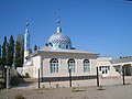 A new mosque in Milyanfan, Ysyk-Ata Destrict
 -
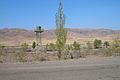 On the Kazakh border
 -
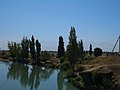 The Chuy River near Korday


References[eedit | eedit soorce]
- ↑ National Committee on Statistics (in Kyrgyz/Russian) Archived 2011-07-22 at the Wayback Machine
- ↑ National Committee on Statistics (in Kyrgyz/Russian) Archived 2010-11-14 at the Wayback Machine
- ↑ National Committee on Statistics (in Kyrgyz/Russian) Archived 2010-11-14 at the Wayback Machine
- ↑ a b National Committee on Statistics (in Kyrgyz/Russian) Archived 2011-07-22 at the Wayback Machine
- ↑ National Committee on Statistics (in Kyrgyz/Russian) Archived 2011-07-22 at the Wayback Machine
- ↑ "Kyrgyzstan - Джалал-Абадская область". Archived frae the original on 2 August 2009. Retrieved 31 Januar 2011.
- ↑ Чуйская областная госадминистрация: Чуйский район Archived 2007-08-21 at the Wayback Machine (The Government of the Chuy Province: Chuy District) (in Roushie)
- ↑ Чуйская областная госадминистрация: Город Токмок Archived 2007-08-27 at the Wayback Machine (The Government of the Chuy Province: City of Tokmok) (in Roushie)
- ↑ [1] Archived 2007-08-24 at the Wayback Machine (The Government of the Chuy Province: The districts of the Chuy Oblast) (in Roushie)
Freemit airtins[eedit | eedit soorce]
| Wikimedia Commons haes media relatit tae Chuy Region. |
- Offeecial wabsteid Archived 2007-06-29 at the Wayback Machine (in Roushie)