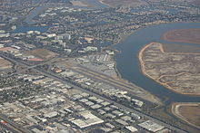
San Carlos Airport (Californie)
| San Carlos Airport | |||||||||||
|---|---|---|---|---|---|---|---|---|---|---|---|
 | |||||||||||
 FAA diagram | |||||||||||
| Summary | |||||||||||
| Airport teep | Public | ||||||||||
| Awner | San Mateo Coonty | ||||||||||
| Serves | San Carlos, Californie | ||||||||||
| Elevation AMSL | 5 ft / 2 m | ||||||||||
| Coordinates | 37°30′43″N 122°14′58″W / 37.51194°N 122.24944°WCoordinates: 37°30′43″N 122°14′58″W / 37.51194°N 122.24944°W | ||||||||||
| Runways | |||||||||||
| |||||||||||
| Statistics (2007) | |||||||||||
| |||||||||||
San Carlos Airport (IATA: SQL, ICAO: KSQL, FAA LID: SQL) is twa mile northeast o San Carlos, Californie, in San Mateo Coonty, Californie.[1][2] The FAA's National Plan of Integrated Airport Systems (NPIAS) classifees San Carlos as a reliever airport for San Francisco Internaitional Airport.
The airport is aff U.S. Route 101. The airport is hame tae Civil Air Patrol West Bay Composite Squadron 192. Next tae the airport is the Hiller Air Museum.
History
[eedit | eedit soorce]San Carlos Airport muivit tae its present location in 1950.[3] The airport haed been aboot a hauf mile soothwast, whaur a Best Buy is nou; this oreeginal San Carlos airport wis opened bi Frank S. Cooley prior tae 1928.[4]
Facilities
[eedit | eedit soorce]San Carlos Airport covers 110 acre (45 ha) at a elevation o 5 feet (2 m). Its ane runwey, 12/30, is 2,600 bi 75 feet (792 x 23 m) asphalt.[1]
A plan tae lenthen the runwey bi 400 feet wis quelled bi neighbors in 1999.[5] Aircraft wi gross wicht in excess o 12,500 lb (5,670 kg) are prohibitit.
San Carlos Airport is hame tae ower 30 aviation relatit businesses. Facilities an FBOs at KSQL include: Rabbit Aviation Services, Surf Air, Zanette Aviation Insurance, West Valley Fleein Club, Bel-Air Internaitional, Air West Aircraft Engines, Diamond Aviation, an the newly opened San Carlos Flight Center.
In 2007 the airport haed 155,273 aircraft operations, average 425 per day: 98% general aviation, 2% air taxi an <1% militar. 372 aircraft wur then based at this airport: 86% single-ingine, 11% multi-ingine, <1% jet an 3% helicopter.[1]
See an aw
[eedit | eedit soorce]References
[eedit | eedit soorce]- ↑ a b c d FAA Airport Master Record for SQL (Form 5010 PDF), effective 2009-07-02.
- ↑ "San Carlos Airport". Geographic Names Information System. United States Geological Survey. Retrieved 3 Mey 2009.
- ↑ "Contact information for Diamond Aviation". Archived frae the original on 6 Mairch 2014. Retrieved 6 September 2014.
- ↑ San Mateo County: Frank S. Cooley PDF
- ↑ "Airport Growth Under Fire". San Jose Mercury News. 4 Januar 1999.
Freemit airtins
[eedit | eedit soorce]| Wikimedia Commons haes media relatit tae San Carlos Airport. |
- San Carlos Airport Archived 2012-02-19 at the Wayback Machine page at San Mateo Coonty Department of Public Works wabsteid
- San Carlos Airport Pilots Association
- FAA Airport Diagram (PDF), effective October 31, 2024
- FAA Terminal Procedures for SQL, effective October 31, 2024
- Resoorces for this airport:
- FAA airport information for SQL
- AirNav airport information for KSQL
- ASN accident history for SQL
- FlightAware airport information an live flicht tracker
- NOAA/NWS latest wather observations
- SkyVector aeronautical chart, Terminal Procedures
