
File:Ukraine under russian occupation.svg

Size of this PNG preview of this SVG file: 800 × 538 pixels. Ither resolutions: 320 × 215 pixels | 640 × 430 pixels | 1,024 × 688 pixels | 1,280 × 860 pixels | 2,560 × 1,720 pixels | 3,780 × 2,540 pixels.
Oreeginal file (SVG file, nominallie 3,780 × 2,540 pixels, file size: 1.36 MB)
Ootline
| Descreeption |
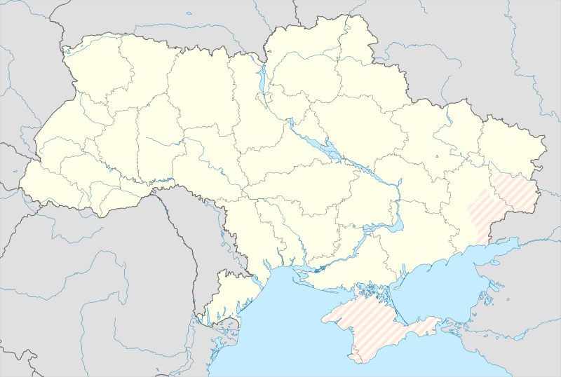
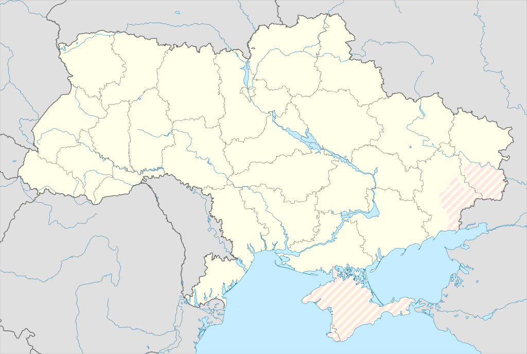
English: Location map of Ukraine under russian occupation.
Українська: Карта України з зонами російської окупації. |
| Date | |
| Soorce |
Own work using: Ukraine adm location map improved.svg, according to
|
| Author | Yakiv Gluck |
| Other versions |
|
| SVG genesis | This locator map was created with Adobe Illustrator. |


Licensin
I, the copyright holder of this work, hereby publish it under the following license:
This file is licensed under the Creative Commons Attribution-Share Alike 4.0 International license.
- Ye are free:
- tae share – tae copy, distribute an transmit the wirk
- tae remix – tae adapt the wirk
- Unner the follaein condeetions:
- attribution – Ye must attribute the wirk in the manner specified bi the author or licensor (but nae in ony way that suggests that thay endorse ye or yer uise o the wirk).
- share alik – If ye alter, transform, or big upon this wirk, ye mey distribute the resultin wirk anly unner the same or seemilar license tae this ane.
File history
Clap oan ae date/time fer tae see the file aes it kithed at that time.
| Date/Time | Thummnail | Dimensions | Uiser | Comment | |
|---|---|---|---|---|---|
| current | 15:45, 9 August 2023 | | 3,780 × 2,540 (1.36 MB) | Dƶoxar | Until the war ends it has no sense to maintain another map with actual frontline |
| 09:32, 25 Julie 2023 |  | 3,780 × 2,540 (1.64 MB) | ASDFPM | Reverted to version as of 17:17, 3 October 2022 (UTC) | |
| 02:45, 12 November 2022 |  | 3,780 × 2,540 (1.36 MB) | Qexypnos | Reverted to version as of 17:02, 3 March 2018 (UTC) | |
| 17:17, 3 October 2022 |  | 3,780 × 2,540 (1.64 MB) | Janitoalevic | Update | |
| 17:02, 3 Mairch 2018 |  | 3,780 × 2,540 (1.36 MB) | Yakiv Gluck | improved using new adm loc map | |
| 01:08, 27 Januar 2018 |  | 1,546 × 1,038 (457 KB) | Yakiv Gluck | {{Information |Description ={{en|Location map of Ukraine under russian occupation.}} {{uk|Карта України з зонами російської окупації.}} |Source =own work, using [[:F... |
Eimage airtins
The'r nae pages airts tae this eimage.
Global file uisage
The follaein ither wikis uise this file:
- Uisage on an.wikipedia.org
- Uisage on de.wikipedia.org
- Uisage on en.wikipedia.org
- Uisage on es.wikipedia.org
View mair global usage o this file.