
File:The ruins of Plean House - geograph.org.uk - 160341.jpg
Nae heier resolution available.
The_ruins_of_Plean_House_-_geograph.org.uk_-_160341.jpg (640 × 480 pixels, file size: 375 KB, MIME type: image/jpeg)
Ootline
| Descreeption |
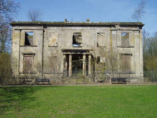
English: The ruins of Plean House. This ruin which was built around 1800 and destroyed by fire in 1972, sits within Plean Country Park which was established in the 1980's. The ruin is now unsafe but was originally built by Francis Simpson who was a Ship's Captain with The Honourable East India Company. |
| Date | |
| Soorce | From geograph.org.uk |
| Author | Kevin Rae |
| Attribution (required by the license) | Kevin Rae / The ruins of Plean House / |
| Camera location | | View this and other nearby images on: OpenStreetMap |
|---|
_heading:45.00&language=sco)
| Object location | | View this and other nearby images on: OpenStreetMap |
|---|
_heading:45.00&language=sco)
Licensin

|
This image was taken from the Geograph project collection. See this photograph's page on the Geograph website for the photographer's contact details. The copyright on this image is owned by Kevin Rae and is licensed for reuse under the Creative Commons Attribution-ShareAlike 2.0 license.
|
This file is licensed under the Creative Commons Attribution-Share Alike 2.0 Generic license.
Attribution: Kevin Rae
- Ye are free:
- tae share – tae copy, distribute an transmit the wirk
- tae remix – tae adapt the wirk
- Unner the follaein condeetions:
- attribution – Ye must attribute the wirk in the manner specified bi the author or licensor (but nae in ony way that suggests that thay endorse ye or yer uise o the wirk).
- share alik – If ye alter, transform, or big upon this wirk, ye mey distribute the resultin wirk anly unner the same or seemilar license tae this ane.
File history
Clap oan ae date/time fer tae see the file aes it kithed at that time.
| Date/Time | Thummnail | Dimensions | Uiser | Comment | |
|---|---|---|---|---|---|
| current | 12:53, 31 Januar 2010 | | 640 × 480 (375 KB) | GeographBot | == {{int:filedesc}} == {{Information |description={{en|1=The ruins of Plean House. This ruin which was built around 1800 and destroyed by fire in 1972, sits within Plean Country Park which was established in the 1980's. The ruin is now unsafe but was orig |
Eimage airtins
The follaein pages airts tae this image:
Global file uisage
The follaein ither wikis uise this file:
- Uisage on de.wikipedia.org
- Uisage on en.wikipedia.org
- Uisage on www.wikidata.org