
File:Savarivermap.png
Nae heier resolution available.
Savarivermap.png (287 × 287 pixels, file size: 37 KB, MIME type: image/png)
Ootline
| Descreeption |
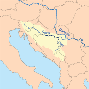
This is a map of the Sava River watershed. I, Karl Musser, created it based on USGS data. Français : Carte de la Posavina. |
| Date | 8 Febuair 2007 (original upload date) |
| Soorce | No machine-readable source provided. Own work assumed (based on copyright claims). |
| Author | No machine-readable author provided. Kmusser assumed (based on copyright claims). |
| Other versions | Savarivermap hr.png |
Licensin
I, the copyright holder of this work, hereby publish it under the following license:
This file is licensed under the Creative Commons Attribution-Share Alike 2.5 Generic license.
- Ye are free:
- tae share – tae copy, distribute an transmit the wirk
- tae remix – tae adapt the wirk
- Unner the follaein condeetions:
- attribution – Ye must attribute the wirk in the manner specified bi the author or licensor (but nae in ony way that suggests that thay endorse ye or yer uise o the wirk).
- share alik – If ye alter, transform, or big upon this wirk, ye mey distribute the resultin wirk anly unner the same or seemilar license tae this ane.
File history
Clap oan ae date/time fer tae see the file aes it kithed at that time.
| Date/Time | Thummnail | Dimensions | Uiser | Comment | |
|---|---|---|---|---|---|
| current | 12:58, 17 December 2013 | | 287 × 287 (37 KB) | Ras67 | cropped |
| 13:23, 8 Februar 2007 |  | 300 × 300 (52 KB) | Kmusser | This is a map of the Sava River watershed. I, Karl Musser, created it based on USGS data. {{self|cc-by-sa-2.5}} Category:Maps of rivers |
Eimage airtins
The'r nae pages airts tae this eimage.
Global file uisage
The follaein ither wikis uise this file:
- Uisage on af.wikipedia.org
- Uisage on am.wikipedia.org
- Uisage on an.wikipedia.org
- Uisage on ar.wikipedia.org
- Uisage on ast.wikipedia.org
- Uisage on azb.wikipedia.org
- Uisage on az.wikipedia.org
- Uisage on be-tarask.wikipedia.org
- Uisage on br.wikipedia.org
- Uisage on bs.wikipedia.org
- Zagreb
- Brčko
- Šamac
- Orašje
- Beograd
- Ljubljana
- Bosna (rijeka)
- Gradiška
- Una
- Vrbas
- Sava
- Geografija Bosne i Hercegovine
- Obrenovac
- Drina
- Posavina
- Slavonski Brod
- Ljubljanica (rijeka)
- Županja
- Bosut
- Tinja
- Geografija Hrvatske
- Sunja (rijeka)
- Sremska Mitrovica
- Sisak
- Kranj
- Sutla
- Orljava
- Kupa
- Šablon:Geokutija/vrsta/Rijeka
- Brka (rijeka)
- Ukrina
- Šabac
- Brežice
- Krško
- Litija
- Trbovlje
- Jesenice
- Šablon:Sava
View mair global usage o this file.