
File:Saint-Barthélemy Island topographic map-fr.svg

Size of this PNG preview of this SVG file: 800 × 533 pixels. Ither resolutions: 320 × 213 pixels | 640 × 427 pixels | 1,024 × 683 pixels | 1,280 × 853 pixels | 2,560 × 1,707 pixels | 5,208 × 3,472 pixels.
Oreeginal file (SVG file, nominallie 5,208 × 3,472 pixels, file size: 6.7 MB)
Ootline
| Descreeption |
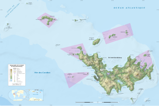
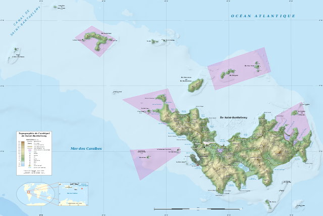
English: Topographic map in French of the Caribbean archipelago of Saint Barthélemy.
Note: the shaded relief is a raster image embedded in the SVG file. Français : Carte topographique en français de l'archipel de Saint-Barthélemy dans les Petites Antilles. Notes : le relief ombré est une image bitmap embarquée dans le fichier SVG.
|
||
| Date | 2010-07, updated 2024-01 | ||
| Soorce |
Ain wirk
|
||
| Author | Eric Gaba (Sting - fr:Sting) | ||
| Permission (Reuisin this file) |
|
||
| Other versions |
|


| Camera location | | View this and other nearby images on: OpenStreetMap |
|---|

|
This SVG file contains embedded text that can be translated into your language, using any capable SVG editor, text editor or the SVG Translate tool. For more information see: About translating SVG files. |
Licensin
Eric Gaba (Wikimedia Commons user Sting), the copyright holder of this work, hereby publishes it under the following license:
This file is licensed under the Creative Commons Attribution-Share Alike 4.0 International license.
Attribution: Eric Gaba (Wikimedia Commons user Sting)
- Ye are free:
- tae share – tae copy, distribute an transmit the wirk
- tae remix – tae adapt the wirk
- Unner the follaein condeetions:
- attribution – Ye must attribute the wirk in the manner specified bi the author or licensor (but nae in ony way that suggests that thay endorse ye or yer uise o the wirk).
- share alik – If ye alter, transform, or big upon this wirk, ye mey distribute the resultin wirk anly unner the same or seemilar license tae this ane.
File history
Clap oan ae date/time fer tae see the file aes it kithed at that time.
| Date/Time | Thummnail | Dimensions | Uiser | Comment | |
|---|---|---|---|---|---|
| current | 01:55, 26 Januar 2024 | | 5,208 × 3,472 (6.7 MB) | Sting | Completely new map using updated data; same geographic limits as previous version |
| 23:43, 17 October 2015 |  | 2,430 × 1,620 (848 KB) | Sting | Using NASA SRTM 1 topographic data | |
| 19:00, 29 Julie 2010 |  | 2,430 × 1,620 (815 KB) | Sting | {== {{int:filedesc}} == {{Location|17|55|00|N|62|52|00|W|scale:50000}} <br/> {{Information |Description={{en|Topographic map in French of the Caribbean archipelago of Saint Barthélemy.<br/> ''Note: the shaded relief is a raster |
Eimage airtins
The'r nae pages airts tae this eimage.
Global file uisage
The follaein ither wikis uise this file:
- Uisage on af.wikipedia.org
- Uisage on ar.wikipedia.org
- Uisage on ast.wikipedia.org
- Uisage on bs.wikipedia.org
- Uisage on de.wikipedia.org
- Uisage on en.wikipedia.org
- Uisage on eo.wikipedia.org
- Uisage on es.wikipedia.org
- Uisage on eu.wikipedia.org
- Uisage on fa.wikipedia.org
- Uisage on fr.wikipedia.org
- Uisage on gl.wikipedia.org
- Uisage on hu.wikipedia.org
- Uisage on id.wikipedia.org
- Uisage on incubator.wikimedia.org
- Uisage on it.wikipedia.org
- Uisage on kk.wikipedia.org
- Uisage on lt.wikipedia.org
- Uisage on nl.wikipedia.org
- Uisage on pl.wikipedia.org
- Uisage on ru.wikipedia.org
- Uisage on sv.wikipedia.org
- Uisage on ta.wikipedia.org
- Uisage on th.wikipedia.org
- Uisage on to.wikipedia.org
- Uisage on uk.wikipedia.org
- Uisage on ur.wikipedia.org
- Uisage on uz.wikipedia.org
- Uisage on vi.wikipedia.org
- Uisage on www.wikidata.org