
File:Puncak Jaya glaciers 1850-2003 evolution map-fr.gif
Nae heier resolution available.
Puncak_Jaya_glaciers_1850-2003_evolution_map-fr.gif (511 × 590 pixels, file size: 2.45 MB, MIME type: image/gif, luip't, 41 frames, 18 s)
This image has been assessed using the Quality image guidelines and is considered a Quality image.
|
Ootline
| Descreeption |
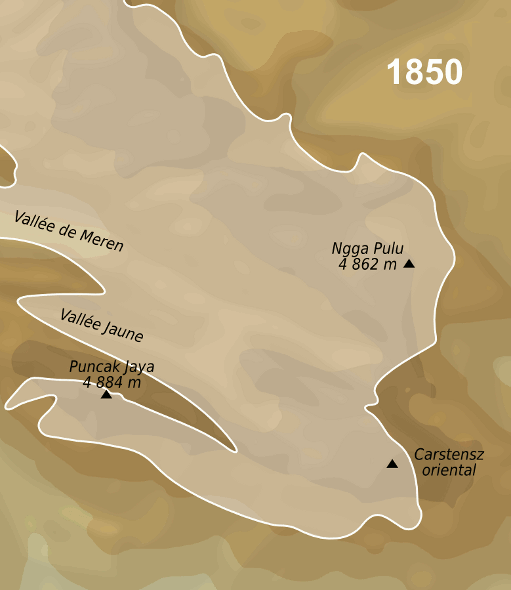
English: Evolution map of Puncak Jaya glaciers between the middle of 19th century and 2003.
Français : Carte de l'évolution des glaciers du Puncak Jaya, entre le milieu du 19è siècle et 2003. |
| Date | |
| Soorce |
travail personnel (own work). Sources :
|
| Author | Sémhur |
| Object location | | View this and other nearby images on: OpenStreetMap |
|---|
Licensin
I, the copyright holder of this work, hereby publish it under the following licenses:

|
Permission is grantit tae copy, distribute an/or modify this document unner the terms o the GNU Free Documentation License, Version 1.2 or ony later version published bi the Free Software Foundation; wi no Invariant Sections, no Front-Cover Texts, an no Back-Cover Texts. A copy o the license is includit in the section enteetled GNU Free Documentation License. |
This file is licensed under the Creative Commons Attribution-Share Alike 3.0 Unported, 2.5 Generic, 2.0 Generic and 1.0 Generic license.
- Ye are free:
- tae share – tae copy, distribute an transmit the wirk
- tae remix – tae adapt the wirk
- Unner the follaein condeetions:
- attribution – Ye must attribute the wirk in the manner specified bi the author or licensor (but nae in ony way that suggests that thay endorse ye or yer uise o the wirk).
- share alik – If ye alter, transform, or big upon this wirk, ye mey distribute the resultin wirk anly unner the same or seemilar license tae this ane.
Ye mey select the license o yer choice.
File history
Clap oan ae date/time fer tae see the file aes it kithed at that time.
| Date/Time | Thummnail | Dimensions | Uiser | Comment | |
|---|---|---|---|---|---|
| current | 15:12, 15 Januar 2012 | | 511 × 590 (2.45 MB) | Sémhur | 3 - Again... |
| 16:01, 28 Apryle 2010 |  | 520 × 600 (1.96 MB) | Sémhur | 2 - Temporary ugly smaller size because of the animated gifs violating 12.5MP rule. | |
| 18:25, 8 Apryle 2009 |  | 779 × 899 (3.49 MB) | Sémhur | {{Information |Description={{en|1=Evolution map of Puncak Jaya glaciers between the middle of 19th century and 2003.}} {{fr|1=Carte de l'évolution des glaciers du Puncak Jaya, entre le milieu du 19è siècle et 200 |
Eimage airtins
The'r nae pages airts tae this eimage.
Global file uisage
The follaein ither wikis uise this file:
- Uisage on ast.wikipedia.org
- Uisage on bg.wikipedia.org
- Uisage on cs.wikipedia.org
- Uisage on de.wikipedia.org
- Uisage on de.wikivoyage.org
- Uisage on el.wikipedia.org
- Uisage on en.wikipedia.org
- Uisage on es.wikipedia.org
- Uisage on fr.wikipedia.org
- Uisage on hi.wikipedia.org
- Uisage on id.wikipedia.org
- Uisage on nl.wikipedia.org
- Uisage on pt.wikipedia.org
- Uisage on sv.wikipedia.org
- Uisage on uk.wikipedia.org
- Uisage on zh.wikipedia.org