
File:Pays Gallo.svg

Size of this PNG preview of this SVG file: 800 × 564 pixels. Ither resolutions: 320 × 225 pixels | 640 × 451 pixels | 1,024 × 721 pixels | 1,280 × 902 pixels | 2,560 × 1,804 pixels | 1,029 × 725 pixels.
Oreeginal file (SVG file, nominallie 1,029 × 725 pixels, file size: 519 KB)
Ootline
| Descreeption |
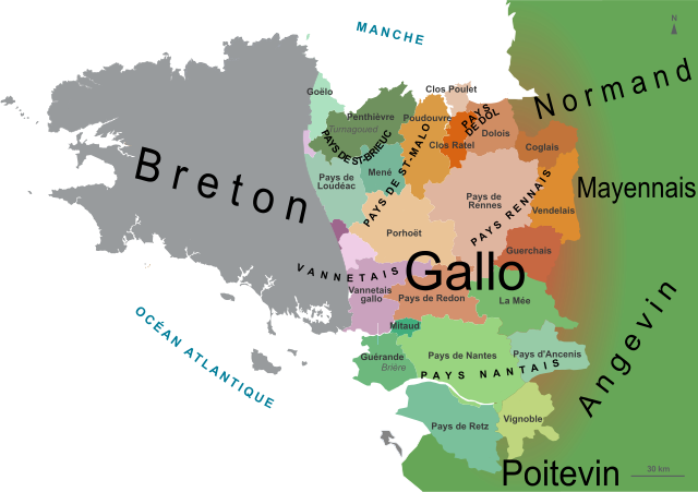
English: Map of the Gallo speaking area in Brittany, France, with the traditional counties and neighbouring languages. Français : Carte du pays gallo en Bretagne, avec les pays traditionnels et les langues voisines. |
| Date | |
| Soorce | Derivative works of this file: France Pays bretons map.svg, by : Pethrus |
| Author | Oie blanche |
I, the copyright holder of this work, hereby publish it under the following licenses:
This file is licensed under the Creative Commons Attribution-Share Alike 3.0 Unported, 2.5 Generic, 2.0 Generic and 1.0 Generic license.
- Ye are free:
- tae share – tae copy, distribute an transmit the wirk
- tae remix – tae adapt the wirk
- Unner the follaein condeetions:
- attribution – Ye must attribute the wirk in the manner specified bi the author or licensor (but nae in ony way that suggests that thay endorse ye or yer uise o the wirk).
- share alik – If ye alter, transform, or big upon this wirk, ye mey distribute the resultin wirk anly unner the same or seemilar license tae this ane.

|
Permission is grantit tae copy, distribute an/or modify this document unner the terms o the GNU Free Documentation License, Version 1.2 or ony later version published bi the Free Software Foundation; wi no Invariant Sections, no Front-Cover Texts, an no Back-Cover Texts. A copy o the license is includit in the section enteetled GNU Free Documentation License. |
Ye mey select the license o yer choice.
Original upload log
This image is a derivative work of the following images:
- File:France_Pays_bretons_map.jpg licensed with Cc-by-sa-3.0,2.5,2.0,1.0, GFDL
- 2010-03-31T12:59:09Z Pethrus 1500x1189 (835023 Bytes) {{Information |Description={{en|Map of the traditionnal regions of Bretagne (France)}}{{fr|Carte des pays traditionnels bretons}} |Source=[http://www.geobreizh.com www.geobreizh.com], Mikael Bodlore-Penlaez |Date=2010-03-30 |
- File:France Pays bretons map.svg licensed with Cc-by-sa-3.0,2.5,2.0,1.0, GFDL
File history
Clap oan ae date/time fer tae see the file aes it kithed at that time.
| Date/Time | Thummnail | Dimensions | Uiser | Comment | |
|---|---|---|---|---|---|
| current | 09:28, 24 Mey 2013 | | 1,029 × 725 (519 KB) | Oie blanche | Text. |
| 16:50, 11 Mairch 2013 |  | 1,029 × 725 (482 KB) | Oie blanche | text position. | |
| 16:47, 11 Mairch 2013 |  | 1,029 × 725 (482 KB) | Oie blanche | User created page with UploadWizard |
Eimage airtins
The'r nae pages airts tae this eimage.
Global file uisage
The follaein ither wikis uise this file:
- Uisage on an.wikipedia.org
- Uisage on ca.wikipedia.org
- Uisage on en.wikipedia.org
- Uisage on frr.wikipedia.org
- Uisage on gl.wikipedia.org
- Uisage on it.wikipedia.org
- Uisage on ja.wikipedia.org
- Uisage on oc.wikipedia.org
- Uisage on pl.wikipedia.org
- Uisage on pms.wikipedia.org
- Uisage on simple.wikipedia.org
- Uisage on sr.wikipedia.org
- Uisage on vi.wikipedia.org