
File:Mapa Myodes glareolus.png

Size o this luikower: 800 × 407 pixels. Ither resolutions: 320 × 163 pixels | 640 × 325 pixels | 1,024 × 521 pixels | 1,280 × 651 pixels | 2,753 × 1,400 pixels.
Oreeginal file (2,753 × 1,400 pixels, file size: 148 KB, MIME type: image/png)
Ootline
| Descreeption |
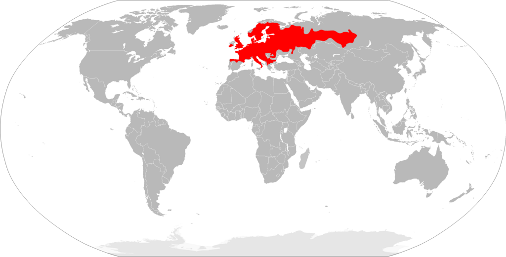
English: Range map of bank vole (Myodes glareolus).
Español: Mapa de distribución del topillo rojo (Myodes glareolus). |
| Date | |
| Soorce | Ain wirk |
| Author | Osado |
Data source: IUCN
Licensin
| I, the copyright holder of this work, release this work into the public domain. This applies worldwide. In some countries this may not be legally possible; if so: I grant anyone the right to use this work for any purpose, without any conditions, unless such conditions are required by law. |
File history
Clap oan ae date/time fer tae see the file aes it kithed at that time.
| Date/Time | Thummnail | Dimensions | Uiser | Comment | |
|---|---|---|---|---|---|
| current | 22:07, 20 Mairch 2018 | | 2,753 × 1,400 (148 KB) | Maphobbyist | South Sudan border |
| 11:57, 17 Februar 2010 |  | 2,753 × 1,400 (151 KB) | Osado | {{Information |Description={{en|1=Range map of bank vole (''Myodes glareolus'').}} {{es|1=Mapa de distribución del topillo rojo (''Myodes glareolus'').}} |Source={{own}} |Author=Osado |Date=2010 |Permission= |other_versions= }} Data source |
Eimage airtins
The follaein pages airts tae this image:
Global file uisage
The follaein ither wikis uise this file:
- Uisage on an.wikipedia.org
- Uisage on arz.wikipedia.org
- Uisage on ast.wikipedia.org
- Uisage on avk.wikipedia.org
- Uisage on be-tarask.wikipedia.org
- Uisage on bg.wikipedia.org
- Uisage on ca.wikipedia.org
- Uisage on ceb.wikipedia.org
- Uisage on cs.wikipedia.org
- Uisage on cy.wikipedia.org
- Uisage on de.wikipedia.org
- Uisage on en.wikipedia.org
- Uisage on es.wikipedia.org
- Uisage on et.wikipedia.org
- Uisage on eu.wikipedia.org
- Uisage on fi.wikipedia.org
- Uisage on fr.wikipedia.org
- Liste des mammifères en France métropolitaine
- Liste des mammifères en Belgique
- Liste des mammifères en Espagne
- Liste des mammifères en Suisse
- Liste des mammifères au Luxembourg
- Liste des mammifères en Italie
- Liste des mammifères en Allemagne
- Liste des mammifères au Royaume-Uni
- Liste des mammifères aux Pays-Bas européens
- Liste des mammifères en Roumanie
- Liste des mammifères en Norvège
- Liste des mammifères en Grèce
- Liste des mammifères en Autriche
- Liste des mammifères en Pologne
- Liste des mammifères en Andorre
- Liste des mammifères au Danemark
- Liste des mammifères en Irlande
- Liste des mammifères en Suède
- Liste des mammifères en Tchéquie
- Liste des mammifères en Finlande
- Liste des mammifères en Croatie
- Liste des mammifères en Hongrie
- Liste des mammifères en Ukraine
- Liste des mammifères à Saint-Marin
- Liste des mammifères au Liechtenstein
- Liste des mammifères en Serbie
View mair global usage o this file.