
File:Manchukuo map 1939.svg

Size of this PNG preview of this SVG file: 634 × 387 pixels. Ither resolutions: 320 × 195 pixels | 640 × 391 pixels | 1,024 × 625 pixels | 1,280 × 781 pixels | 2,560 × 1,563 pixels.
Oreeginal file (SVG file, nominallie 634 × 387 pixels, file size: 2.23 MB)
| Descreeption |
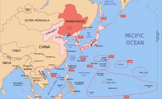
English: A map of the Manchukuo, 1939-09-01. Dates shown indicate the approximate year that Japan gain control of the possession. Japanese control of territory in China was tenuous. |
| Date | |
| Soorce | |
| Author |
|
| Other versions |
|


I, the copyright holder of this work, hereby publish it under the following licenses:
This file is licensed unner the Creative Commons Attribution-Share Alike 3.0 Unported license.
- Ye are free:
- tae share – tae copy, distribute an transmit the wirk
- tae remix – tae adapt the wirk
- Unner the follaein condeetions:
- attribution – Ye must attribute the wirk in the manner specified bi the author or licensor (but nae in ony way that suggests that thay endorse ye or yer uise o the wirk).
- share alik – If ye alter, transform, or big upon this wirk, ye mey distribute the resultin wirk anly unner the same or seemilar license tae this ane.

|
Permission is grantit tae copy, distribute an/or modify this document unner the terms o the GNU Free Documentation License, Version 1.2 or ony later version published bi the Free Software Foundation; wi no Invariant Sections, no Front-Cover Texts, an no Back-Cover Texts. A copy o the license is includit in the section enteetled GNU Free Documentation License. |
Ye mey select the license o yer choice.
Original upload log
This image is a derivative work of the following images:
- Image:Pacific_Area_-_The_Imperial_Powers_1939_-_Map.svg licensed with Cc-by-sa-3.0, GFDL
- 2008-08-08T01:16:33Z Emok 1039x814 (4678233 Bytes) {{Information |Description= |Source= |Date= |Author= |Permission= |other_versions= }}
- 2008-08-08T00:07:48Z Emok 1039x814 (4669659 Bytes) {{Information |Description= |Source= |Date= |Author= |Permission= |other_versions= }}
- 2008-08-07T05:03:23Z Emok 1039x814 (4669195 Bytes) {{Information |Description= |Source= |Date= |Author= |Permission= |other_versions= }}
- 2008-08-07T04:28:58Z Emok 1039x814 (4623405 Bytes) {{Information |Description= |Source= |Date= |Author= |Permission= |other_versions= }}
- 2008-08-07T04:02:57Z Emok 1039x814 (4602891 Bytes) {{Information |Description= |Source= |Date= |Author= |Permission= |other_versions= }}
- 2008-08-07T03:24:03Z Emok 1039x814 (4669511 Bytes) {{Information |Description= |Source= |Date= |Author= |Permission= |other_versions= }}
- 2008-08-04T16:59:39Z Emok 1039x814 (6442489 Bytes) {{Information |Description= |Source= |Date= |Author= |Permission= |other_versions= }}
- 2008-08-04T05:38:24Z Emok 1039x814 (6427678 Bytes) {{Information |Description= |Source= |Date= |Author= |Permission= |other_versions= }} [[Category:Imperialism]] [[Category:Oceania]]
- 2008-08-04T05:26:00Z Emok 104x82 (4765313 Bytes) {{Information |Description={{en|1=A map of the Imperial Powers of the Pacific, 1939-09-01. }} |Source=*[[:Image:World2Hires_filled_mercator.svg|]] |Date=2008-08-04 05:22 (UTC) |Author=*derivative work: ~~~ *[[:Image:World2Hir
Uploaded with derivativeFX
File history
Clap oan ae date/time fer tae see the file aes it kithed at that time.
| Date/Time | Thummnail | Dimensions | Uiser | Comment | |
|---|---|---|---|---|---|
| current | 14:48, 16 September 2023 | | 634 × 387 (2.23 MB) | KajenCAT | File uploaded using svgtranslate tool (https://svgtranslate.toolforge.org/). Added translation for ca. |
| 15:17, 2 Juin 2023 |  | 634 × 387 (2.2 MB) | SmallJarsWithGreenLabels | re-applying sp changes because this site sucks and gave me the old version of the svg for my second edit | |
| 23:33, 1 Juin 2023 |  | 634 × 387 (2.2 MB) | SmallJarsWithGreenLabels | saipan per user:Geographyinitiative | |
| 23:18, 1 Juin 2023 |  | 634 × 387 (2.19 MB) | SmallJarsWithGreenLabels | sp | |
| 01:37, 27 August 2010 |  | 634 × 387 (2.21 MB) | Splittist | No reason for Xinjiang to have separate borders from China | |
| 23:29, 30 Mey 2009 |  | 634 × 387 (2.21 MB) | SelfQ~commonswiki | Cluttering and removal of key elements is not acceptable. If you want a Chineese version please upload on under its own file name. | |
| 10:44, 17 Mey 2009 |  | 1,300 × 1,201 (864 KB) | Xiamipi | 增加中文说明 | |
| 02:52, 21 August 2008 |  | 634 × 387 (2.21 MB) | Emok | {{Information |Description= |Source= |Date= |Author= |Permission= |other_versions= }} | |
| 02:41, 21 August 2008 |  | 634 × 387 (2.21 MB) | Emok | {{Information |Description= |Source= |Date= |Author= |Permission= |other_versions= }} | |
| 01:41, 8 August 2008 |  | 634 × 387 (2.2 MB) | Emok | {{Information |Description= |Source= |Date= |Author= |Permission= |other_versions= }} |
Eimage airtins
The'r nae pages airts tae this eimage.
Global file uisage
The follaein ither wikis uise this file:
- Uisage on ar.wikipedia.org
- Uisage on azb.wikipedia.org
- Uisage on az.wikipedia.org
- Uisage on bg.wikipedia.org
- Uisage on bs.wikipedia.org
- Uisage on ca.wikipedia.org
- Uisage on da.wikipedia.org
- Uisage on el.wikipedia.org
- Uisage on en.wikipedia.org
- Uisage on fa.wikipedia.org
- Uisage on fr.wikipedia.org
- Uisage on hr.wikipedia.org
- Uisage on hy.wikipedia.org
- Uisage on id.wikipedia.org
- Uisage on it.wikipedia.org
- Uisage on ja.wikipedia.org
- Uisage on ja.wikibooks.org
- Uisage on jv.wikipedia.org
- Uisage on lt.wikipedia.org
- Uisage on lv.wikipedia.org
- Uisage on mk.wikipedia.org
- Uisage on mn.wikipedia.org
- Uisage on ms.wikipedia.org
- Uisage on no.wikipedia.org
- Uisage on pt.wikipedia.org
- Uisage on sh.wikipedia.org
- Uisage on simple.wikipedia.org
- Uisage on sl.wikipedia.org
- Uisage on sr.wikipedia.org
- Uisage on ta.wikipedia.org
- Uisage on uk.wikipedia.org
- Uisage on uz.wikipedia.org