
File:London Postal District.png
Nae heier resolution available.
London_Postal_District.png (561 × 439 pixels, file size: 467 KB, MIME type: image/png)
Ootline
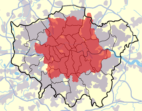
A modified map of Greater London, highlighting the London postal district in red, created by en:User:Jhamez84

|
This image could be re-created using vector graphics as an SVG file. This has several advantages; see Commons:Media for cleanup for more information. If an SVG form of this image is available, please upload it and afterwards replace this template with
{{vector version available|new image name}}.
It is recommended to name the SVG file “London Postal District.svg”—then the template Vector version available (or Vva) does not need the new image name parameter. |
Licensin
| I, the copyright holder of this work, release this work into the public domain. This applies worldwide. In some countries this may not be legally possible; if so: I grant anyone the right to use this work for any purpose, without any conditions, unless such conditions are required by law. |
File history
Clap oan ae date/time fer tae see the file aes it kithed at that time.
| Date/Time | Thummnail | Dimensions | Uiser | Comment | |
|---|---|---|---|---|---|
| current | 09:18, 30 Mairch 2007 | | 561 × 439 (467 KB) | Steff | == Summary == A modified map of Greater London, highlighting the London postal district in red, created by en:User:Jhamez84 == Licensing == {{PD-self}} |
Eimage airtins
The follaein pages airts tae this image:
Global file uisage
The follaein ither wikis uise this file:
- Uisage on ar.wikipedia.org
- Uisage on ceb.wikipedia.org
- Uisage on en.wikipedia.org
- London postal district
- Inner London
- Postal counties of the United Kingdom
- Module:Location map/data/UK Greater London postal/doc
- User:Richardguk/Postcode areas transcluded
- User:Richardguk/N postcode area
- User:Richardguk/NW postcode area
- User:Richardguk/W postcode area
- Greater London
- Module:Location map/data/UK Greater London postal
- Uisage on eu.wikipedia.org
- Uisage on fa.wikipedia.org
- Uisage on fr.wikipedia.org
- Uisage on he.wikipedia.org
- Uisage on hr.wikipedia.org
- Uisage on it.wikipedia.org
- Uisage on ja.wikipedia.org
- Uisage on kn.wikipedia.org
- Uisage on mk.wikipedia.org
- Uisage on ml.wikipedia.org
- Uisage on qu.wikipedia.org
- Uisage on ro.wikipedia.org
- Uisage on si.wikipedia.org
- Uisage on sl.wikipedia.org
- Uisage on war.wikipedia.org