
File:Livingston-Island-location-map.png

Size o this luikower: 800 × 548 pixels. Ither resolutions: 320 × 219 pixels | 640 × 439 pixels | 1,024 × 702 pixels | 1,280 × 877 pixels | 1,669 × 1,144 pixels.
Oreeginal file (1,669 × 1,144 pixels, file size: 151 KB, MIME type: image/png)
Ootline
| Descreeption |
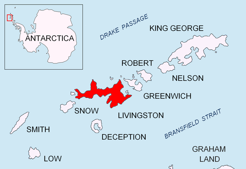
English: Location map of Livingston Island in the South Shetland Islands. |
| Date | |
| Soorce | Ain wirk |
| Author | Apcbg |
Licensin
I, the copyright holder of this work, hereby publish it under the following license:
This file is licensed unner the Creative Commons Attribution-Share Alike 3.0 Unported license.
- Ye are free:
- tae share – tae copy, distribute an transmit the wirk
- tae remix – tae adapt the wirk
- Unner the follaein condeetions:
- attribution – Ye must attribute the wirk in the manner specified bi the author or licensor (but nae in ony way that suggests that thay endorse ye or yer uise o the wirk).
- share alik – If ye alter, transform, or big upon this wirk, ye mey distribute the resultin wirk anly unner the same or seemilar license tae this ane.
File history
Clap oan ae date/time fer tae see the file aes it kithed at that time.
| Date/Time | Thummnail | Dimensions | Uiser | Comment | |
|---|---|---|---|---|---|
| current | 17:23, 24 August 2010 | | 1,669 × 1,144 (151 KB) | Apcbg | + location in Antarctica |
| 18:52, 27 Apryle 2010 |  | 1,669 × 1,144 (5.47 MB) | Apcbg | {{Information |Description={{en|1=Location map of Livingston Island in the South Shetland Islands.}} |Source={{own}} |Author=Apcbg |Date=2010-04-27 |Permission= |other_versions= }} Category:Maps of Antarctica |
Eimage airtins
The'r nae pages airts tae this eimage.
Global file uisage
The follaein ither wikis uise this file:
- Uisage on ar.wikipedia.org
- Uisage on az.wikipedia.org
- Uisage on bg.wikipedia.org
- Берое (хълм)
- Монтана (връх)
- Берковица (ледник)
- Златоградски камък
- Амадок (нос)
- Алеко (нос)
- Емона (залив в Антарктика)
- Пимпирев бряг
- Перуника (ледник)
- Смолян (нос)
- Пимпирев ледник
- Айтос (нос)
- Авитохол (нос)
- Биляр (нос)
- Елемаг (нос)
- Куклен (нос)
- Луковит (нос)
- Мелта (нос)
- Баба Неделя (нос)
- Ронжел (нос)
- Синдел (нос)
- Вазов (нос)
- Яна (нос)
- Хан Аспарух (връх)
- Атанасов нунатак
- Южен Бърдик
- Чирпан (връх)
- Хемус (връх)
- Скравена (залив)
- Uisage on ceb.wikipedia.org
- Uisage on en.wikipedia.org
View mair global usage o this file.