
File:Lismore Island.jpg
Nae heier resolution available.
Lismore_Island.jpg (640 × 480 pixels, file size: 124 KB, MIME type: image/jpeg)
Ootline
| Descreeption |
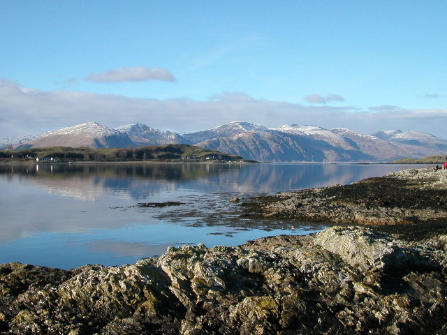
English: Lismore Island and the hills of Kingairloch beyond. The ferry runs from Port Appin on the extreme right of the picture. |
| Date | |
| Soorce | From geograph.org.uk |
| Author | Alan Partridge |
| Permission (Reuisin this file) |
Creative Commons Attribution Share-alike license 2.0 |
| Camera location | | View this and other nearby images on: OpenStreetMap |
|---|
Licensin

|
This image was taken from the Geograph project collection. See this photograph's page on the Geograph website for the photographer's contact details. The copyright on this image is owned by Alan Partridge and is licensed for reuse under the Creative Commons Attribution-ShareAlike 2.0 license.
|
This file is licensed under the Creative Commons Attribution-Share Alike 2.0 Generic license.
Attribution: Alan Partridge
- Ye are free:
- tae share – tae copy, distribute an transmit the wirk
- tae remix – tae adapt the wirk
- Unner the follaein condeetions:
- attribution – Ye must attribute the wirk in the manner specified bi the author or licensor (but nae in ony way that suggests that thay endorse ye or yer uise o the wirk).
- share alik – If ye alter, transform, or big upon this wirk, ye mey distribute the resultin wirk anly unner the same or seemilar license tae this ane.
File history
Clap oan ae date/time fer tae see the file aes it kithed at that time.
| Date/Time | Thummnail | Dimensions | Uiser | Comment | |
|---|---|---|---|---|---|
| current | 08:26, 14 Juin 2021 | | 640 × 480 (124 KB) | Bjh21 | Replace with visually-identical original from Geograph, which should have less generation loss |
| 13:22, 26 December 2005 |  | 640 × 480 (98 KB) | Cactus.man | Lismore Island and the hills of Kingairloch beyond. The ferry runs from Port Appin on the extreme right of the picture. Blah. Photograph by Alan Partridge [http://www.geograph.org.uk/photo/62829] {{Cc-by-sa-2.0}} Category:Scotland [[Category:Islan |
Eimage airtins
The'r nae pages airts tae this eimage.
Global file uisage
The follaein ither wikis uise this file:
- Uisage on br.wikipedia.org
- Uisage on de.wikipedia.org
- Uisage on en.wikipedia.org
- Uisage on fr.wikipedia.org
- Uisage on ga.wikipedia.org
- Uisage on gd.wikipedia.org
- Uisage on he.wikipedia.org
- Uisage on it.wikipedia.org
- Uisage on la.wikipedia.org
- Uisage on nn.wikipedia.org
- Uisage on no.wikipedia.org
- Uisage on pl.wikipedia.org
- Uisage on uk.wikipedia.org